

Schnelle Powerroute
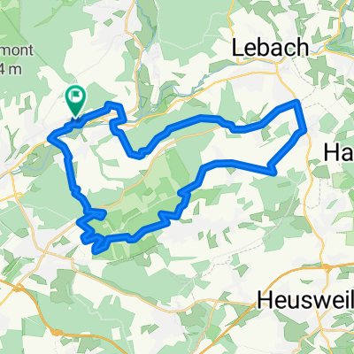
A cycling route starting in Nalbach, Saarland, Germany.
Overview
About this route
Kurz, aber intensiv, da über schmale Pfade und relativ hügelig
- -:--
- Duration
- 11.7 km
- Distance
- 307 m
- Ascent
- 307 m
- Descent
- ---
- Avg. speed
- ---
- Max. altitude

Route quality
Waytypes & surfaces along the route
Waytypes
Track
6.6 km
(57 %)
Quiet road
2.8 km
(24 %)
Surfaces
Paved
3.3 km
(28 %)
Unpaved
7.8 km
(67 %)
Gravel
3.8 km
(33 %)
Unpaved (undefined)
2.4 km
(21 %)
Continue with Bikemap
Use, edit, or download this cycling route
You would like to ride Schnelle Powerroute or customize it for your own trip? Here is what you can do with this Bikemap route:
Free features
- Save this route as favorite or in collections
- Copy & plan your own version of this route
- Sync your route with Garmin or Wahoo
Premium features
Free trial for 3 days, or one-time payment. More about Bikemap Premium.
- Navigate this route on iOS & Android
- Export a GPX / KML file of this route
- Create your custom printout (try it for free)
- Download this route for offline navigation
Discover more Premium features.
Get Bikemap PremiumFrom our community
Other popular routes starting in Nalbach
 Düppenweiler - Hüttersdorf 13.05.2022
- Distance
- 23.7 km
- Ascent
- 530 m
- Descent
- 530 m
- Location
- Nalbach, Saarland, Germany
 40 Km RSF Körprich 2015
- Distance
- 45.1 km
- Ascent
- 208 m
- Descent
- 209 m
- Location
- Nalbach, Saarland, Germany
 Auf und Ab 2022 - 75 km Permanente der Radsportfreunde Körprich e.V.
- Distance
- 75.4 km
- Ascent
- 868 m
- Descent
- 860 m
- Location
- Nalbach, Saarland, Germany
 Über die Höhen des Saarlandes 2007 - RTF der Radsportfreunde Körprich e.V. - 76 km Strecke
- Distance
- 78.2 km
- Ascent
- 611 m
- Descent
- 612 m
- Location
- Nalbach, Saarland, Germany
 Nordsaarlandfahrt - RTF der Radsportfreunde Körprich e.V. - 74 km Strecke
- Distance
- 77.6 km
- Ascent
- 881 m
- Descent
- 880 m
- Location
- Nalbach, Saarland, Germany
 kleine Runde Düppenweiler 15km
- Distance
- 14.8 km
- Ascent
- 336 m
- Descent
- 222 m
- Location
- Nalbach, Saarland, Germany
 Über die Höhen des Saarlandes 2007 - RTF der Radsportfreunde Körprich e.V. - 46 km Strecke
- Distance
- 49.7 km
- Ascent
- 285 m
- Descent
- 285 m
- Location
- Nalbach, Saarland, Germany
 Hoxberg und teilweise Schluchtenpfad
- Distance
- 30.1 km
- Ascent
- 405 m
- Descent
- 405 m
- Location
- Nalbach, Saarland, Germany
Open it in the app