Start Oltingue Rundtour durchs Elsass
A cycling route starting in Ferrette, Alsace-Champagne-Ardenne-Lorraine, France.
Overview
About this route
Meine Ebike-Touren führen nach Möglichkeit über verkehrsarme Strassen, Radwege, asphaltierte Nebenstrassen, durch Wiesen, Felder und Wälder. Tagestouren sind ca. 70-90 km, reine Fahrzeit ca. 4-5 Stunden.
Startpunkt in Oltingue, Parkplatz bei der Kirche.
- -:--
- Duration
- 93.4 km
- Distance
- 428 m
- Ascent
- 428 m
- Descent
- ---
- Avg. speed
- ---
- Avg. speed
Route quality
Waytypes & surfaces along the route
Waytypes
Road
67.3 km
(72 %)
Quiet road
11.8 km
(13 %)
Surfaces
Paved
51 km
(55 %)
Unpaved
0 km
(<1 %)
Asphalt
51 km
(55 %)
Paved (undefined)
0.1 km
(<1 %)
Continue with Bikemap
Use, edit, or download this cycling route
You would like to ride Start Oltingue Rundtour durchs Elsass or customize it for your own trip? Here is what you can do with this Bikemap route:
Free features
- Save this route as favorite or in collections
- Copy & plan your own version of this route
- Sync your route with Garmin or Wahoo
Premium features
Free trial for 3 days, or one-time payment. More about Bikemap Premium.
- Navigate this route on iOS & Android
- Export a GPX / KML file of this route
- Create your custom printout (try it for free)
- Download this route for offline navigation
Discover more Premium features.
Get Bikemap PremiumFrom our community
Other popular routes starting in Ferrette
- 3-Tage Tour RSV Breisach Tag 3: Le Petit Kohlberg - Breisach
- Distance
- 123 km
- Ascent
- 405 m
- Descent
- 903 m
- Location
- Ferrette, Alsace-Champagne-Ardenne-Lorraine, France
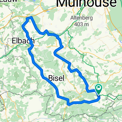
- Sundgau-Vélo 8 - le tour du Glaserberg
- Distance
- 47.1 km
- Ascent
- 612 m
- Descent
- 610 m
- Location
- Ferrette, Alsace-Champagne-Ardenne-Lorraine, France
- Lucelle -Burg
- Distance
- 22.9 km
- Ascent
- 341 m
- Descent
- 454 m
- Location
- Ferrette, Alsace-Champagne-Ardenne-Lorraine, France
- 58km from Oltingue
- Distance
- 57.9 km
- Ascent
- 590 m
- Descent
- 592 m
- Location
- Ferrette, Alsace-Champagne-Ardenne-Lorraine, France
- TET-CH-Section1-20181026
- Distance
- 189.2 km
- Ascent
- 3,205 m
- Descent
- 3,074 m
- Location
- Ferrette, Alsace-Champagne-Ardenne-Lorraine, France
- Start Oltingue Rundtour durchs Elsass
- Distance
- 93.4 km
- Ascent
- 428 m
- Descent
- 428 m
- Location
- Ferrette, Alsace-Champagne-Ardenne-Lorraine, France
- Ferrette Lucelle Delemont StUrsanne Vaufrey Porrentruy Ferrette
- Distance
- 142 km
- Ascent
- 1,419 m
- Descent
- 1,425 m
- Location
- Ferrette, Alsace-Champagne-Ardenne-Lorraine, France
- MoulinNeuf-Ferrette-Altkirch-Charmoille
- Distance
- 90.9 km
- Ascent
- 787 m
- Descent
- 786 m
- Location
- Ferrette, Alsace-Champagne-Ardenne-Lorraine, France
Open it in the app