

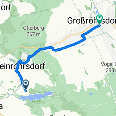
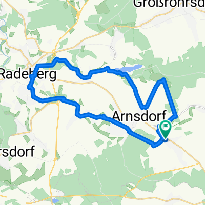
Overview
About this route
Bike tour for all members
- all age groups, moderate pace, break at the beer garden
- -:--
- Duration
- 38.5 km
- Distance
- 196 m
- Ascent
- 200 m
- Descent
- ---
- Avg. speed
- ---
- Max. altitude
Part of
Leviva
1 stage
Route quality
Waytypes & surfaces along the route
Waytypes
Track
13.5 km
(35 %)
Quiet road
12.7 km
(33 %)
Surfaces
Paved
19.6 km
(51 %)
Unpaved
11.5 km
(30 %)
Asphalt
18.1 km
(47 %)
Gravel
8.1 km
(21 %)
Continue with Bikemap
Use, edit, or download this cycling route
You would like to ride LevivaRadTour I Juni16 or customize it for your own trip? Here is what you can do with this Bikemap route:
Free features
- Save this route as favorite or in collections
- Copy & plan your own version of this route
- Sync your route with Garmin or Wahoo
Premium features
Free trial for 3 days, or one-time payment. More about Bikemap Premium.
- Navigate this route on iOS & Android
- Export a GPX / KML file of this route
- Create your custom printout (try it for free)
- Download this route for offline navigation
Discover more Premium features.
Get Bikemap PremiumFrom our community
Other popular routes starting in Arnsdorf
 Rund um Sachsenmilch
- Distance
- 11.8 km
- Ascent
- 104 m
- Descent
- 105 m
- Location
- Arnsdorf, Saxony, Germany
 Bankomat Arnsdorfer Straße, Großröhrsdorf nach Mühlstraße, Großröhrsdorf
- Distance
- 6.1 km
- Ascent
- 45 m
- Descent
- 37 m
- Location
- Arnsdorf, Saxony, Germany
 Vormittagsprogramm
- Distance
- 17.9 km
- Ascent
- 152 m
- Descent
- 154 m
- Location
- Arnsdorf, Saxony, Germany
 Rossendor-Stolpen-Stürza-Weißig-Rossendorf
- Distance
- 46.2 km
- Ascent
- 312 m
- Descent
- 312 m
- Location
- Arnsdorf, Saxony, Germany
 Geosache-Runde Westlausitz
- Distance
- 19.4 km
- Ascent
- 149 m
- Descent
- 150 m
- Location
- Arnsdorf, Saxony, Germany
 karlswald-Bahndamm-hüttertal-tanneberg-massenei
- Distance
- 22.5 km
- Ascent
- 104 m
- Descent
- 102 m
- Location
- Arnsdorf, Saxony, Germany
 Arbeitsweg durch die Heide
- Distance
- 18.2 km
- Ascent
- 144 m
- Descent
- 258 m
- Location
- Arnsdorf, Saxony, Germany
 Rundweg Arnsdorf-Radeberg-Stausee Wallroda
- Distance
- 24.4 km
- Ascent
- 149 m
- Descent
- 149 m
- Location
- Arnsdorf, Saxony, Germany
Open it in the app