

Jakľofski bicigeľ 2016
A cycling route starting in Gelnica, Košice Region, Slovakia.
Overview
About this route
Changes compared to last year:
-
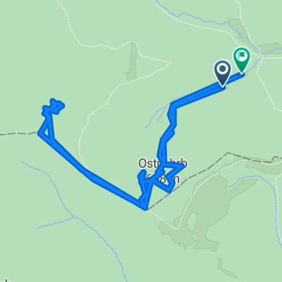
After 300 m, continue along the lower edge of the meadow towards the solar power plant, then go up along the fence and connect in a sharp right-hand curve to the climb from last year.
-
At kilometer 10.5, continue along the forest road (last year we turned left into a steep descent, below which there was a refreshment point). Between kilometers 11 and 13, a short climb to the saddle at the SNP memorial has been added.
-
At kilometer 13.5 at the Zemičky saddle, there will be a refreshment station. From the saddle, we turn right into a steep descent above Kojšov, first through the forest, then after exiting onto the meadow again to the right, under the meadow again to the right onto the forest road, which leads under Folkmárska rock up to Veľký Folkmar. Here, at about 20 km, begins a downhill section already known from past years.
-
At kilometer 21, we turn sharply left and continue along the path towards the water station, briefly and steeply climbing above the water station and then descending along the forest road to the ford. After the water (as it may be...) we come out onto the asphalt and enter the village of V. Folkmar. We pass through the local roads to the start of the already known climb around the horses :-) At the top, we head into the descent across the meadow beneath the electricity poles and continue across the meadow down to the small creek, to the other shore and along the forest road into the village.
-
Further, no changes.
- -:--
- Duration
- 30 km
- Distance
- 927 m
- Ascent
- 931 m
- Descent
- ---
- Avg. speed
- ---
- Max. altitude
Route highlights
Points of interest along the route
Point of interest after 13.6 km
občerstvovačka
Continue with Bikemap
Use, edit, or download this cycling route
You would like to ride Jakľofski bicigeľ 2016 or customize it for your own trip? Here is what you can do with this Bikemap route:
Free features
- Save this route as favorite or in collections
- Copy & plan your own version of this route
- Sync your route with Garmin or Wahoo
Premium features
Free trial for 3 days, or one-time payment. More about Bikemap Premium.
- Navigate this route on iOS & Android
- Export a GPX / KML file of this route
- Create your custom printout (try it for free)
- Download this route for offline navigation
Discover more Premium features.
Get Bikemap PremiumFrom our community
Other popular routes starting in Gelnica
 Okolo Ružína
- Distance
- 44.7 km
- Ascent
- 948 m
- Descent
- 953 m
- Location
- Gelnica, Košice Region, Slovakia
 My favorite
- Distance
- 16 km
- Ascent
- 808 m
- Descent
- 803 m
- Location
- Gelnica, Košice Region, Slovakia
 Palenčáreň 2015 "krátka"
- Distance
- 31.9 km
- Ascent
- 787 m
- Descent
- 787 m
- Location
- Gelnica, Košice Region, Slovakia
 Mníšek nad Hnilcom-Úhorná-Úhornianske sedlo-sedlo medzi Bielimi Skalami a Hekerovou- Stará Voda- Mníšek nad Hnilcom
- Distance
- 47.8 km
- Ascent
- 982 m
- Descent
- 974 m
- Location
- Gelnica, Košice Region, Slovakia
 48.902, 21.107 to 48.903, 21.109
- Distance
- 8.9 km
- Ascent
- 535 m
- Descent
- 568 m
- Location
- Gelnica, Košice Region, Slovakia
 jaklovce_kurtovaskala_plejsy_thurzov_jaklovce
- Distance
- 27.6 km
- Ascent
- 676 m
- Descent
- 676 m
- Location
- Gelnica, Košice Region, Slovakia
 Palenčáreň 2015 "dlhá"
- Distance
- 63.4 km
- Ascent
- 1,425 m
- Descent
- 1,425 m
- Location
- Gelnica, Košice Region, Slovakia
 Prakovce- Polianka- Prakovce
- Distance
- 17.1 km
- Ascent
- 634 m
- Descent
- 634 m
- Location
- Gelnica, Košice Region, Slovakia
Open it in the app