Barhill and back
- 57.2 km
- 395 m
- 387 m
- Stranraer, Scotland, United Kingdom
A cycling route starting in Stranraer, Scotland, United Kingdom.
Overview
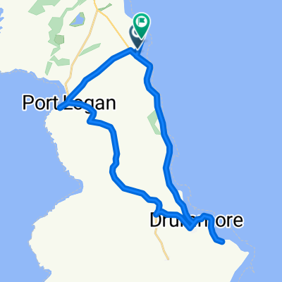
This 15th section of St Ninian's Way starts at Glenluce crossroads and heads north- west along road and track for 2 km to Glenluce Abbey. Continue along east bank of the Water of Luce 4 km to Cruise (crossroads with Southern Upland Way) and continue 2 km to New Luce (Conservation Village)
Alternatively, for an extra 6 km, at Cruise take the Southern Upland Way going East for 5 km to the road and waterfall on the Cross Water of Luce, then take the minor road back to New Luce.
Gently undulating along the Luce valley
Also part of the Whithorn Way - http://www.whithornway.org . courtesy of the WWSG where a detailed route description with grid references is available.
For a map overview of Part 1 and Part 2 of St Ninian’s Way please go to https://www.bikemap.net/en/route/3548129-st-ninians-way-carlisle-to-st-andrews-part-1-carlisle-to-whithorn/
St Ninian’s Way is one of the great pilgrim routes in Scotland to St Andrews - The Way of St Andrews - For other routes see http://www.thewayofstandrews.com
created this 9 years ago
Route quality
Road
6.8 km
(83 %)
Quiet road
0.8 km
(10 %)
Access road
0.6 km
(7 %)
Paved
1.2 km
(15 %)
Asphalt
1.2 km
(15 %)
Undefined
7 km
(85 %)
Route highlights
Glenluce Abbey
Joins Southern Upland Way , with 6 km detour to New Luce
Continue with Bikemap
You would like to ride St Ninian's Way - Glenluce to New Luce or customize it for your own trip? Here is what you can do with this Bikemap route:
Free trial for 3 days, or one-time payment. More about Bikemap Premium.
Discover more Premium features.
Get Bikemap PremiumFrom our community
Open it in the app