

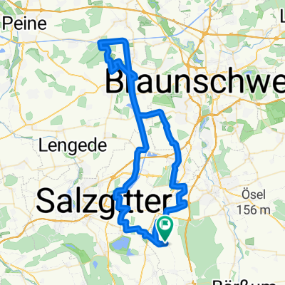
Stichkanal-Mittellandkanal-Runde
A cycling route starting in Cramme, Lower Saxony, Germany.
Overview
About this route
Sehr gut zu fahren, kaum Holperstrecken, kleine Strassen mit wenig Verkehr.
- -:--
- Duration
- 69 km
- Distance
- 120 m
- Ascent
- 123 m
- Descent
- ---
- Avg. speed
- ---
- Max. altitude

Route quality
Waytypes & surfaces along the route
Waytypes
Track
24.4 km
(35 %)
Road
16.4 km
(24 %)
Surfaces
Paved
26.6 km
(38 %)
Unpaved
25.8 km
(37 %)
Asphalt
20.4 km
(30 %)
Gravel
9.5 km
(14 %)
Continue with Bikemap
Use, edit, or download this cycling route
You would like to ride Stichkanal-Mittellandkanal-Runde or customize it for your own trip? Here is what you can do with this Bikemap route:
Free features
- Save this route as favorite or in collections
- Copy & plan your own version of this route
- Sync your route with Garmin or Wahoo
Premium features
Free trial for 3 days, or one-time payment. More about Bikemap Premium.
- Navigate this route on iOS & Android
- Export a GPX / KML file of this route
- Create your custom printout (try it for free)
- Download this route for offline navigation
Discover more Premium features.
Get Bikemap PremiumFrom our community
Other popular routes starting in Cramme
 Stichkanal-Mittellandkanal-Runde
- Distance
- 69 km
- Ascent
- 120 m
- Descent
- 123 m
- Location
- Cramme, Lower Saxony, Germany
 Cramme, Hedwigsburg, Dorstadt
- Distance
- 24.9 km
- Ascent
- 225 m
- Descent
- 225 m
- Location
- Cramme, Lower Saxony, Germany
 Goslar Bassgeige
- Distance
- 58.7 km
- Ascent
- 437 m
- Descent
- 435 m
- Location
- Cramme, Lower Saxony, Germany
 130316 ODER1
- Distance
- 22.2 km
- Ascent
- 255 m
- Descent
- 255 m
- Location
- Cramme, Lower Saxony, Germany
 Hornburg
- Distance
- 59.6 km
- Ascent
- 314 m
- Descent
- 314 m
- Location
- Cramme, Lower Saxony, Germany
 Wolfenbüttel Süd 33Km 272Hm
- Distance
- 33 km
- Ascent
- 273 m
- Descent
- 272 m
- Location
- Cramme, Lower Saxony, Germany
 PR-Tour-58b -58km-520hm
- Distance
- 57.9 km
- Ascent
- 553 m
- Descent
- 555 m
- Location
- Cramme, Lower Saxony, Germany
 Adershein -Lauenförde 2.1
- Distance
- 119.1 km
- Ascent
- 819 m
- Descent
- 826 m
- Location
- Cramme, Lower Saxony, Germany
Open it in the app