

🚴♀️E*Bike🇦🇹 Kaltern - Leifers
A cycling route starting in Cornaiano, Trentino-Alto Adige, Italy.
Overview
About this route
TEASI track
- -:--
- Duration
- 71.7 km
- Distance
- 499 m
- Ascent
- 506 m
- Descent
- ---
- Avg. speed
- ---
- Max. altitude

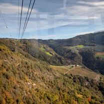
Route photos


Route quality
Waytypes & surfaces along the route
Waytypes
Cycleway
30.8 km
(43 %)
Quiet road
23 km
(32 %)
Surfaces
Paved
55.9 km
(78 %)
Asphalt
53.8 km
(75 %)
Paved (undefined)
2.2 km
(3 %)
Undefined
15.8 km
(22 %)
Continue with Bikemap
Use, edit, or download this cycling route
You would like to ride 🚴♀️E*Bike🇦🇹 Kaltern - Leifers or customize it for your own trip? Here is what you can do with this Bikemap route:
Free features
- Save this route as favorite or in collections
- Copy & plan your own version of this route
- Sync your route with Garmin or Wahoo
Premium features
Free trial for 3 days, or one-time payment. More about Bikemap Premium.
- Navigate this route on iOS & Android
- Export a GPX / KML file of this route
- Create your custom printout (try it for free)
- Download this route for offline navigation
Discover more Premium features.
Get Bikemap PremiumFrom our community
Other popular routes starting in Cornaiano
 Frangard Passeier Tal und zurück
- Distance
- 97.4 km
- Ascent
- 852 m
- Descent
- 865 m
- Location
- Cornaiano, Trentino-Alto Adige, Italy
 Kaltern - Sigmundskron
- Distance
- 37.9 km
- Ascent
- 228 m
- Descent
- 222 m
- Location
- Cornaiano, Trentino-Alto Adige, Italy
 Fragant - Girlan (Singletrail)
- Distance
- 8.2 km
- Ascent
- 278 m
- Descent
- 295 m
- Location
- Cornaiano, Trentino-Alto Adige, Italy
 Große Montigglerrunde
- Distance
- 22 km
- Ascent
- 413 m
- Descent
- 413 m
- Location
- Cornaiano, Trentino-Alto Adige, Italy
 Weinstraße 19, Eppan an der Weinstraße. nach Weinstraße 66, Frangart
- Distance
- 35.4 km
- Ascent
- 845 m
- Descent
- 856 m
- Location
- Cornaiano, Trentino-Alto Adige, Italy
 Dag 2, Hotel Spitaler to Pension Dolomiten
- Distance
- 27.8 km
- Ascent
- 49 m
- Descent
- 81 m
- Location
- Cornaiano, Trentino-Alto Adige, Italy
 Frangart Ritten und zurpck
- Distance
- 68.8 km
- Ascent
- 1,749 m
- Descent
- 1,759 m
- Location
- Cornaiano, Trentino-Alto Adige, Italy
 Bozen - Kaltern
- Distance
- 36.4 km
- Ascent
- 218 m
- Descent
- 219 m
- Location
- Cornaiano, Trentino-Alto Adige, Italy
Open it in the app