Lavis - Bezzecca
A cycling route starting in Lavis, Trentino-Alto Adige, Italy.
Overview
About this route
Srtori's Hotel Lavis - Villaggio Santa Lucia
- -:--
- Duration
- 76.5 km
- Distance
- 783 m
- Ascent
- 279 m
- Descent
- ---
- Avg. speed
- ---
- Max. altitude
Route quality
Waytypes & surfaces along the route
Waytypes
Cycleway
41.3 km
(54 %)
Quiet road
21.4 km
(28 %)
Surfaces
Paved
68.1 km
(89 %)
Unpaved
4.6 km
(6 %)
Asphalt
67.3 km
(88 %)
Gravel
1.5 km
(2 %)
Continue with Bikemap
Use, edit, or download this cycling route
You would like to ride Lavis - Bezzecca or customize it for your own trip? Here is what you can do with this Bikemap route:
Free features
- Save this route as favorite or in collections
- Copy & plan your own version of this route
- Sync your route with Garmin or Wahoo
Premium features
Free trial for 3 days, or one-time payment. More about Bikemap Premium.
- Navigate this route on iOS & Android
- Export a GPX / KML file of this route
- Create your custom printout (try it for free)
- Download this route for offline navigation
Discover more Premium features.
Get Bikemap PremiumFrom our community
Other popular routes starting in Lavis
- TRENTO - CICLABILE VALSUGANA RACCORDO
- Distance
- 35.6 km
- Ascent
- 417 m
- Descent
- 213 m
- Location
- Lavis, Trentino-Alto Adige, Italy
- Lavis - Bezzecca
- Distance
- 76.5 km
- Ascent
- 783 m
- Descent
- 279 m
- Location
- Lavis, Trentino-Alto Adige, Italy
- Nice route to Passo Manghen (2000m)
- Distance
- 71.9 km
- Ascent
- 3,056 m
- Descent
- 1,953 m
- Location
- Lavis, Trentino-Alto Adige, Italy
- 1te Tag "Trentino-Belluno
- Distance
- 59.8 km
- Ascent
- 1,076 m
- Descent
- 1,050 m
- Location
- Lavis, Trentino-Alto Adige, Italy
- Dolomite West - East (Trento - Carnia)
- Distance
- 352.1 km
- Ascent
- 5,474 m
- Descent
- 5,424 m
- Location
- Lavis, Trentino-Alto Adige, Italy
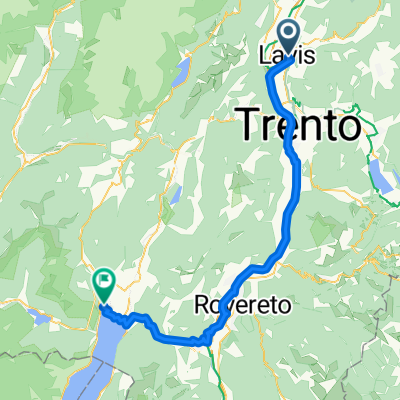
- Runde ins Feimstal (Trentino)
- Distance
- 85.1 km
- Ascent
- 3,564 m
- Descent
- 3,563 m
- Location
- Lavis, Trentino-Alto Adige, Italy
- 5. Etappe Laris nach Rovereto
- Distance
- 36.6 km
- Ascent
- 50 m
- Descent
- 84 m
- Location
- Lavis, Trentino-Alto Adige, Italy
- Val di Cembra
- Distance
- 83.3 km
- Ascent
- 2,901 m
- Descent
- 2,672 m
- Location
- Lavis, Trentino-Alto Adige, Italy
Open it in the app