

Halhul el cabir 0911
A cycling route starting in Za‘tarah, West Bank, Palestine.
Overview
About this route
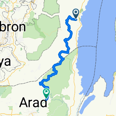
Halhul el cabir Circular, starting from Matzuki Dragot
- -:--
- Duration
- 28.8 km
- Distance
- 588 m
- Ascent
- 588 m
- Descent
- ---
- Avg. speed
- ---
- Max. altitude
Continue with Bikemap
Use, edit, or download this cycling route
You would like to ride Halhul el cabir 0911 or customize it for your own trip? Here is what you can do with this Bikemap route:
Free features
- Save this route as favorite or in collections
- Copy & plan your own version of this route
- Sync your route with Garmin or Wahoo
Premium features
Free trial for 3 days, or one-time payment. More about Bikemap Premium.
- Navigate this route on iOS & Android
- Export a GPX / KML file of this route
- Create your custom printout (try it for free)
- Download this route for offline navigation
Discover more Premium features.
Get Bikemap PremiumFrom our community
Other popular routes starting in Za‘tarah
 dargot
- Distance
- 31.2 km
- Ascent
- 754 m
- Descent
- 754 m
- Location
- Za‘tarah, West Bank, Palestine
 Radreise Israel - 05
- Distance
- 108.8 km
- Ascent
- 1,259 m
- Descent
- 872 m
- Location
- Za‘tarah, West Bank, Palestine
 off road 2016 day 4
- Distance
- 62.5 km
- Ascent
- 913 m
- Descent
- 601 m
- Location
- Za‘tarah, West Bank, Palestine
 צומת מצוקי דרגות to צומת מצוקי דרגות
- Distance
- 8 km
- Ascent
- 374 m
- Descent
- 74 m
- Location
- Za‘tarah, West Bank, Palestine
 Halhul el cabir 0911
- Distance
- 28.8 km
- Ascent
- 588 m
- Descent
- 588 m
- Location
- Za‘tarah, West Bank, Palestine
 enduru day2 op5
- Distance
- 47.6 km
- Ascent
- 316 m
- Descent
- 320 m
- Location
- Za‘tarah, West Bank, Palestine
 enduro day2 op 5
- Distance
- 55 km
- Ascent
- 310 m
- Descent
- 316 m
- Location
- Za‘tarah, West Bank, Palestine
 Radreise Israel: 05
- Distance
- 108.8 km
- Ascent
- 1,240 m
- Descent
- 841 m
- Location
- Za‘tarah, West Bank, Palestine
Open it in the app