

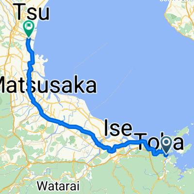
Toba tsu
A cycling route starting in Toba, Mie, Japan.
Overview
About this route
- -:--
- Duration
- 57.8 km
- Distance
- 79 m
- Ascent
- 81 m
- Descent
- ---
- Avg. speed
- ---
- Max. altitude

Route highlights
Points of interest along the route
Accommodation after 50.1 km
Camping Hamakaze
Continue with Bikemap
Use, edit, or download this cycling route
You would like to ride Toba tsu or customize it for your own trip? Here is what you can do with this Bikemap route:
Free features
- Save this route as favorite or in collections
- Copy & plan your own version of this route
- Sync your route with Garmin or Wahoo
Premium features
Free trial for 3 days, or one-time payment. More about Bikemap Premium.
- Navigate this route on iOS & Android
- Export a GPX / KML file of this route
- Create your custom printout (try it for free)
- Download this route for offline navigation
Discover more Premium features.
Get Bikemap PremiumFrom our community
Other popular routes starting in Toba
 Cycling the Length of Japan: Kansai
- Distance
- 208.7 km
- Ascent
- 2,398 m
- Descent
- 2,398 m
- Location
- Toba, Mie, Japan
 Toba tsu
- Distance
- 57.8 km
- Ascent
- 79 m
- Descent
- 81 m
- Location
- Toba, Mie, Japan
 Ise-Farm
- Distance
- 92 km
- Ascent
- 761 m
- Descent
- 490 m
- Location
- Toba, Mie, Japan
 5: Toba to Kyoto
- Distance
- 151.7 km
- Ascent
- 465 m
- Descent
- 438 m
- Location
- Toba, Mie, Japan
 Ise-Shima cycling festival 2019
- Distance
- 59.7 km
- Ascent
- 820 m
- Descent
- 821 m
- Location
- Toba, Mie, Japan
 Length of Japan Toba-Tsu
- Distance
- 57.7 km
- Ascent
- 243 m
- Descent
- 242 m
- Location
- Toba, Mie, Japan
 CJ06 鳥羽~津(2016)
- Distance
- 48.8 km
- Ascent
- 82 m
- Descent
- 85 m
- Location
- Toba, Mie, Japan
 Length of Japan Toba-Tsu
- Distance
- 57.8 km
- Ascent
- 79 m
- Descent
- 81 m
- Location
- Toba, Mie, Japan
Open it in the app