

Test
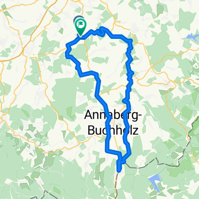
A cycling route starting in Burkhardtsdorf, Saxony, Germany.
Overview
About this route
- -:--
- Duration
- 3.9 km
- Distance
- 73 m
- Ascent
- 9 m
- Descent
- ---
- Avg. speed
- ---
- Max. altitude
Route quality
Waytypes & surfaces along the route
Waytypes
Quiet road
1.8 km
(45 %)
Track
0.4 km
(10 %)
Surfaces
Paved
3.1 km
(79 %)
Unpaved
0.4 km
(10 %)
Asphalt
3.1 km
(78 %)
Gravel
0.4 km
(10 %)
Continue with Bikemap
Use, edit, or download this cycling route
You would like to ride Test or customize it for your own trip? Here is what you can do with this Bikemap route:
Free features
- Save this route as favorite or in collections
- Copy & plan your own version of this route
- Sync your route with Garmin or Wahoo
Premium features
Free trial for 3 days, or one-time payment. More about Bikemap Premium.
- Navigate this route on iOS & Android
- Export a GPX / KML file of this route
- Create your custom printout (try it for free)
- Download this route for offline navigation
Discover more Premium features.
Get Bikemap PremiumFrom our community
Other popular routes starting in Burkhardtsdorf
 Einsiedel via Zwönitz zurück
- Distance
- 53.9 km
- Ascent
- 462 m
- Descent
- 589 m
- Location
- Burkhardtsdorf, Saxony, Germany
 Burkhardtsdorf - Fichtelberg - Plattenberg
- Distance
- 117.2 km
- Ascent
- 1,520 m
- Descent
- 1,419 m
- Location
- Burkhardtsdorf, Saxony, Germany
 Amselring 14, Burkhardtsdorf nach Thumer Straße 71, Geyer
- Distance
- 17 km
- Ascent
- 459 m
- Descent
- 242 m
- Location
- Burkhardtsdorf, Saxony, Germany
 hieckis
- Distance
- 86.5 km
- Ascent
- 884 m
- Descent
- 1,045 m
- Location
- Burkhardtsdorf, Saxony, Germany
 auersberg - fichtelberg
- Distance
- 145 km
- Ascent
- 1,481 m
- Descent
- 1,481 m
- Location
- Burkhardtsdorf, Saxony, Germany
 Zigaretten holen
- Distance
- 89.2 km
- Ascent
- 789 m
- Descent
- 837 m
- Location
- Burkhardtsdorf, Saxony, Germany
 Klaffenbach Adorf Meinersdorf Klaffenbach
- Distance
- 16.2 km
- Ascent
- 373 m
- Descent
- 373 m
- Location
- Burkhardtsdorf, Saxony, Germany
 Klaffenbach - Talsperre Stooberg
- Distance
- 10.9 km
- Ascent
- 234 m
- Descent
- 156 m
- Location
- Burkhardtsdorf, Saxony, Germany
Open it in the app