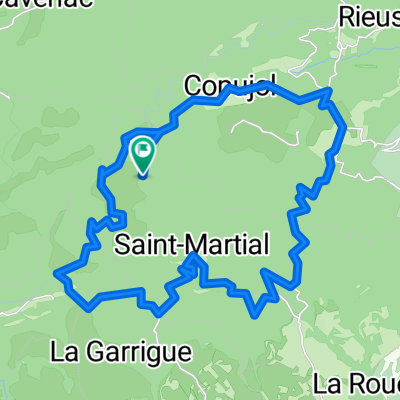
Route du Sud Etape 1
A cycling route starting in Saint-Pons-de-Thomières, Occitanie, France.
Overview
About this route
- -:--
- Duration
- 198.5 km
- Distance
- 1,391 m
- Ascent
- 1,606 m
- Descent
- ---
- Avg. speed
- ---
- Max. altitude
Route quality
Waytypes & surfaces along the route
Waytypes
Road
29.8 km
(15 %)
Quiet road
19.8 km
(10 %)
Surfaces
Paved
45.7 km
(23 %)
Asphalt
45.7 km
(23 %)
Undefined
152.8 km
(77 %)
Continue with Bikemap
Use, edit, or download this cycling route
You would like to ride Route du Sud Etape 1 or customize it for your own trip? Here is what you can do with this Bikemap route:
Free features
- Save this route as favorite or in collections
- Copy & plan your own version of this route
- Split it into stages to create a multi-day tour
- Sync your route with Garmin or Wahoo
Premium features
Free trial for 3 days, or one-time payment. More about Bikemap Premium.
- Navigate this route on iOS & Android
- Export a GPX / KML file of this route
- Create your custom printout (try it for free)
- Download this route for offline navigation
Discover more Premium features.
Get Bikemap PremiumFrom our community
Other popular routes starting in Saint-Pons-de-Thomières
st pons de thomieres to Saissac- Distance
- 84.2 km
- Ascent
- 931 m
- Descent
- 711 m
- Location
- Saint-Pons-de-Thomières, Occitanie, France
Saint-Pons-de-Thomières - Lamalou-les-Bains- Distance
- 72.9 km
- Ascent
- 1,178 m
- Descent
- 1,284 m
- Location
- Saint-Pons-de-Thomières, Occitanie, France
2019 Mazamet-Herepian- Distance
- 13.2 km
- Ascent
- 177 m
- Descent
- 63 m
- Location
- Saint-Pons-de-Thomières, Occitanie, France
Leg 2 Day 4- Distance
- 121.8 km
- Ascent
- 966 m
- Descent
- 1,150 m
- Location
- Saint-Pons-de-Thomières, Occitanie, France
Ride Day 22—3 Oct 2005—34220 St-Pons-de-Thomières to 81320 Murat-sur-Vèbre- Distance
- 40.5 km
- Ascent
- 1,041 m
- Descent
- 511 m
- Location
- Saint-Pons-de-Thomières, Occitanie, France
BALADE AUTOUR DE ST P0NS- Distance
- 79.1 km
- Ascent
- 1,158 m
- Descent
- 1,158 m
- Location
- Saint-Pons-de-Thomières, Occitanie, France
Etape 16– De Lacan à Minerve - Itinéraire Sud- Distance
- 18.2 km
- Ascent
- 501 m
- Descent
- 790 m
- Location
- Saint-Pons-de-Thomières, Occitanie, France
Leg 2 Day 4 kurz- Distance
- 113.1 km
- Ascent
- 869 m
- Descent
- 1,053 m
- Location
- Saint-Pons-de-Thomières, Occitanie, France
Open it in the app

