

Mangfall Runde Um Weyarn
A cycling route starting in Weyarn, Bavaria, Germany.
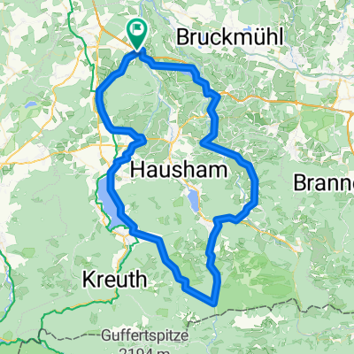
Overview
About this route
Abwechslungsreiche und technisch anspruchsvolle Runde an der Manfall entlang. Nur für Mountainbikes geeignet und eher nur etwas für Fullies. Ein guter Anfang für die Runde ist Weyarn, da man an der Autobahn den Wagen gut parken kann. Schnell geht es von dort in den Wald und an der Mangfall entlang. Durch den Wald fährt man auf teilweisen schmalen und von Baumwurzeln durchzogenen Wegen. Alles sehr hügelig, macht aber viel Spass. Vor dem letzten Drittel, dass auf kleinen und kaum befahrenen Strassen stattfindet, muss man eine Steigung mit 14% bewältigen um nach Sonderdilching zu gelangen. Belohnt wird das allerdings mit einer rasanten Abfahrt auf der anderen Seite Richtung Fentbach. In Gasthaus Lindl kann man einkehren und hervorragend speisen. Von dort ist es später zum Wagen auch nicht mehr weit und es geht bis auf den Anfang immer Berg ab.
- -:--
- Duration
- 46.9 km
- Distance
- 461 m
- Ascent
- 464 m
- Descent
- ---
- Avg. speed
- ---
- Max. altitude
Route highlights
Points of interest along the route
Point of interest after 35.2 km
Continue with Bikemap
Use, edit, or download this cycling route
You would like to ride Mangfall Runde Um Weyarn or customize it for your own trip? Here is what you can do with this Bikemap route:
Free features
- Save this route as favorite or in collections
- Copy & plan your own version of this route
- Sync your route with Garmin or Wahoo
Premium features
Free trial for 3 days, or one-time payment. More about Bikemap Premium.
- Navigate this route on iOS & Android
- Export a GPX / KML file of this route
- Create your custom printout (try it for free)
- Download this route for offline navigation
Discover more Premium features.
Get Bikemap PremiumFrom our community
Other popular routes starting in Weyarn
 Mitterdarching - Valepp
- Distance
- 89.6 km
- Ascent
- 876 m
- Descent
- 879 m
- Location
- Weyarn, Bavaria, Germany
 Brucker Straße 2, Weyarn nach Holzkirchner Straße 12, Sachsenkam
- Distance
- 30.6 km
- Ascent
- 411 m
- Descent
- 345 m
- Location
- Weyarn, Bavaria, Germany
 Mühlthal, Valley nach Schliersee
- Distance
- 22.7 km
- Ascent
- 3,302 m
- Descent
- 3,124 m
- Location
- Weyarn, Bavaria, Germany
 Miesbach - Tegernsee - Spitzingsee - Miesbach
- Distance
- 84.3 km
- Ascent
- 935 m
- Descent
- 935 m
- Location
- Weyarn, Bavaria, Germany
 Taubenberg Seehamersee Runde
- Distance
- 33.3 km
- Ascent
- 618 m
- Descent
- 618 m
- Location
- Weyarn, Bavaria, Germany
 Irschenberg-Tegernsee-Valepp-Elbach-Niklaskreuth
- Distance
- 109.5 km
- Ascent
- 1,027 m
- Descent
- 1,025 m
- Location
- Weyarn, Bavaria, Germany
 Weyern-Seehamersee
- Distance
- 21.8 km
- Ascent
- 286 m
- Descent
- 289 m
- Location
- Weyarn, Bavaria, Germany
 MTB-Taubenberg-Seehamersee-33km
- Distance
- 33.3 km
- Ascent
- 528 m
- Descent
- 528 m
- Location
- Weyarn, Bavaria, Germany
Open it in the app