
Rulle-Sichkanal-Lechtingen-Rulle
A cycling route starting in Wallenhorst, Lower Saxony, Germany.
Overview
About this route
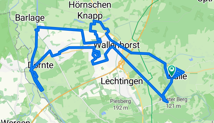
Wir fahren in Rulle an der Apotheke los, fahren dann die L109 ricchting Wallenhorst um von da mit etwas Umweg zum Kanal in Hollage zu kommen. Dort fahren wir ein Stück (teils unbefestigt, man kann aber auf nen Radweg in 30 m entfernung ausweichen) direkt am kanal entlang bis zur Hollager Schleuse. Dort kehren wir um und gahren jetzt den schon eben angesprochenen Radweg entlang zurück bis zu der Stelle wo wir dem Kanal das erse mal begegnet sind.
Dann etwas Zick-Zack durch Hollage, Wallenhorst und Lechtingen, um dann den Gruthügel herab wieder nach Rulle und unserem Ausgangspunkt, die Apotheke zu Rulle zu gelangen.
- -:--
- Duration
- 32.1 km
- Distance
- 147 m
- Ascent
- 147 m
- Descent
- ---
- Avg. speed
- ---
- Max. altitude
Continue with Bikemap
Use, edit, or download this cycling route
You would like to ride Rulle-Sichkanal-Lechtingen-Rulle or customize it for your own trip? Here is what you can do with this Bikemap route:
Free features
- Save this route as favorite or in collections
- Copy & plan your own version of this route
- Sync your route with Garmin or Wahoo
Premium features
Free trial for 3 days, or one-time payment. More about Bikemap Premium.
- Navigate this route on iOS & Android
- Export a GPX / KML file of this route
- Create your custom printout (try it for free)
- Download this route for offline navigation
Discover more Premium features.
Get Bikemap PremiumFrom our community
Other popular routes starting in Wallenhorst
 Rulle-Sichkanal-Lechtingen-Rulle
- Distance
- 32.1 km
- Ascent
- 147 m
- Descent
- 147 m
- Location
- Wallenhorst, Lower Saxony, Germany
 Piesberg
- Distance
- 18 km
- Ascent
- 146 m
- Descent
- 188 m
- Location
- Wallenhorst, Lower Saxony, Germany
 RTF Engter 75 km
- Distance
- 72.1 km
- Ascent
- 318 m
- Descent
- 318 m
- Location
- Wallenhorst, Lower Saxony, Germany
 Über Stock und Stein
- Distance
- 33.6 km
- Ascent
- 321 m
- Descent
- 324 m
- Location
- Wallenhorst, Lower Saxony, Germany
 Wallenhorster Route
- Distance
- 20 km
- Ascent
- 102 m
- Descent
- 97 m
- Location
- Wallenhorst, Lower Saxony, Germany
 Rulle- Vpn der Stadt bis zur Bauernschaft
- Distance
- 43.2 km
- Ascent
- 241 m
- Descent
- 230 m
- Location
- Wallenhorst, Lower Saxony, Germany
 Kleine Runde
- Distance
- 32.5 km
- Ascent
- 109 m
- Descent
- 108 m
- Location
- Wallenhorst, Lower Saxony, Germany
 Samstagsrunde
- Distance
- 109.8 km
- Ascent
- 507 m
- Descent
- 509 m
- Location
- Wallenhorst, Lower Saxony, Germany
Open it in the app