

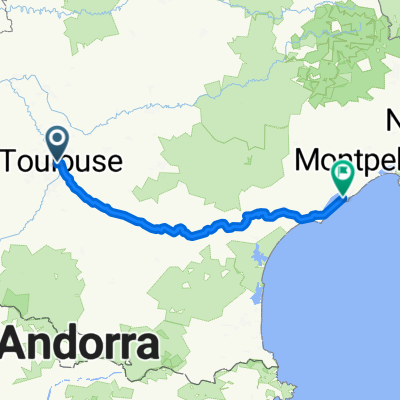
Toulouse - Foix
A cycling route starting in Toulouse, Occitanie, France.
Overview
About this route
Be carefoul, the google maps got me lost in the 'forest' before Labarthe-sur-Lezu as you can see in the photos. I rode a 5 km circle on the route made for the mountain bikes or cross. it was quite nice, beautiful nature, just not made for the road bike :)
- -:--
- Duration
- 93.2 km
- Distance
- 244 m
- Ascent
- 21 m
- Descent
- ---
- Avg. speed
- ---
- Max. altitude

Route photos

Route quality
Waytypes & surfaces along the route
Waytypes
Quiet road
16.8 km
(18 %)
Road
13.1 km
(14 %)
Surfaces
Paved
51.3 km
(55 %)
Unpaved
4.7 km
(5 %)
Asphalt
48.5 km
(52 %)
Ground
3.7 km
(4 %)
Continue with Bikemap
Use, edit, or download this cycling route
You would like to ride Toulouse - Foix or customize it for your own trip? Here is what you can do with this Bikemap route:
Free features
- Save this route as favorite or in collections
- Copy & plan your own version of this route
- Split it into stages to create a multi-day tour
- Sync your route with Garmin or Wahoo
Premium features
Free trial for 3 days, or one-time payment. More about Bikemap Premium.
- Navigate this route on iOS & Android
- Export a GPX / KML file of this route
- Create your custom printout (try it for free)
- Download this route for offline navigation
Discover more Premium features.
Get Bikemap PremiumFrom our community
Other popular routes starting in Toulouse
 Les coteaux du lauraguais
- Distance
- 106.3 km
- Ascent
- 610 m
- Descent
- 610 m
- Location
- Toulouse, Occitanie, France
 Boucle Toulouse Grenade Mondonville
- Distance
- 64.3 km
- Ascent
- 150 m
- Descent
- 150 m
- Location
- Toulouse, Occitanie, France
 Canal du midi
- Distance
- 242.7 km
- Ascent
- 116 m
- Descent
- 241 m
- Location
- Toulouse, Occitanie, France
 Erotica
- Distance
- 58.4 km
- Ascent
- 560 m
- Descent
- 560 m
- Location
- Toulouse, Occitanie, France
 toulouse-foix -13
- Distance
- 87.4 km
- Ascent
- 353 m
- Descent
- 99 m
- Location
- Toulouse, Occitanie, France
 Canal du midi
- Distance
- 242.7 km
- Ascent
- 108 m
- Descent
- 237 m
- Location
- Toulouse, Occitanie, France
 Pechbusque, Merville, Rebigue, La Plaine, Donneville, Deyme, Pompertuzat
- Distance
- 46.5 km
- Ascent
- 732 m
- Descent
- 732 m
- Location
- Toulouse, Occitanie, France
 Ruta 1
- Distance
- 27.4 km
- Ascent
- 506 m
- Descent
- 506 m
- Location
- Toulouse, Occitanie, France
Open it in the app