
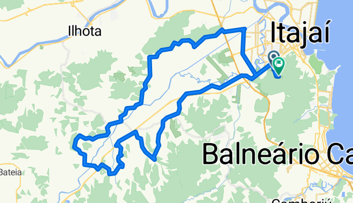
Itajaí Rural
A cycling route starting in Itajaí, Santa Catarina, Brazil.
Overview
About this route
- -:--
- Duration
- 58.5 km
- Distance
- 260 m
- Ascent
- 254 m
- Descent
- ---
- Avg. speed
- ---
- Max. altitude

Continue with Bikemap
Use, edit, or download this cycling route
You would like to ride Itajaí Rural or customize it for your own trip? Here is what you can do with this Bikemap route:
Free features
- Save this route as favorite or in collections
- Copy & plan your own version of this route
- Sync your route with Garmin or Wahoo
Premium features
Free trial for 3 days, or one-time payment. More about Bikemap Premium.
- Navigate this route on iOS & Android
- Export a GPX / KML file of this route
- Create your custom printout (try it for free)
- Download this route for offline navigation
Discover more Premium features.
Get Bikemap PremiumFrom our community
Other popular routes starting in Itajaí
 De Rua Alvaro Beraldi 460 a Rua Alvaro Beraldi 44
- Distance
- 24.6 km
- Ascent
- 158 m
- Descent
- 162 m
- Location
- Itajaí, Santa Catarina, Brazil
 De Rua Alvaro Beraldi 44 a Rua Alvaro Beraldi 400
- Distance
- 23.6 km
- Ascent
- 107 m
- Descent
- 110 m
- Location
- Itajaí, Santa Catarina, Brazil
 casa aff😎😎
- Distance
- 3.3 km
- Ascent
- 14 m
- Descent
- 14 m
- Location
- Itajaí, Santa Catarina, Brazil
 De Avenida Coronel Marcos Konder, 264, Itajaí a Rua Constantino Lucas Pereira, 49, Itajaí
- Distance
- 38.2 km
- Ascent
- 0 m
- Descent
- 14 m
- Location
- Itajaí, Santa Catarina, Brazil
 Rota para Rua Alvaro Beraldi 400
- Distance
- 23.5 km
- Ascent
- 119 m
- Descent
- 127 m
- Location
- Itajaí, Santa Catarina, Brazil
 Itajaí Rural
- Distance
- 58.5 km
- Ascent
- 260 m
- Descent
- 254 m
- Location
- Itajaí, Santa Catarina, Brazil
 Ilhota a Cachoeira dos Macacos
- Distance
- 63.4 km
- Ascent
- 339 m
- Descent
- 290 m
- Location
- Itajaí, Santa Catarina, Brazil
 primeiro dia
- Distance
- 9 km
- Ascent
- 376 m
- Descent
- 385 m
- Location
- Itajaí, Santa Catarina, Brazil
Open it in the app