

Stoppomat Hoher Meißner
A cycling route starting in Bad Sooden-Allendorf, Hesse, Germany.
Overview
About this route
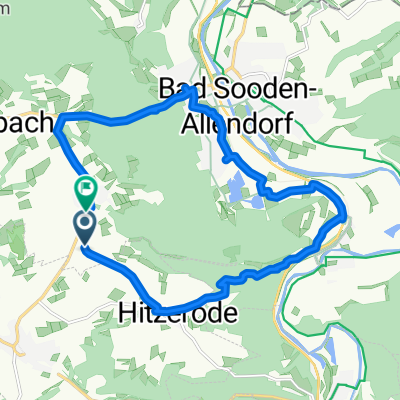
Bergzeitmessung für Amateure und Profis
<br />Am „Hohen Meißner“ im Werratal steht Deutschlands nördlichste, fest installierte Zeitmessanlage für Radsportler:
Auf 7,8 km müssen 450 Höhenmeter mit einer durchschnittlichen Steigung von 6,1% überwunden werden (maximale Steigung 20 %).
Gestartet wird in 37290 Meißner-Abterode in der Ortsmitte (L 3241) und Ziel ist der große Parkplatz auf dem Hochplateau des "Hohen Meißners".
- -:--
- Duration
- 7.8 km
- Distance
- 491 m
- Ascent
- 27 m
- Descent
- ---
- Avg. speed
- ---
- Max. altitude
Continue with Bikemap
Use, edit, or download this cycling route
You would like to ride Stoppomat Hoher Meißner or customize it for your own trip? Here is what you can do with this Bikemap route:
Free features
- Save this route as favorite or in collections
- Copy & plan your own version of this route
- Sync your route with Garmin or Wahoo
Premium features
Free trial for 3 days, or one-time payment. More about Bikemap Premium.
- Navigate this route on iOS & Android
- Export a GPX / KML file of this route
- Create your custom printout (try it for free)
- Download this route for offline navigation
Discover more Premium features.
Get Bikemap PremiumFrom our community
Other popular routes starting in Bad Sooden-Allendorf
 2020-08-22: Werra - Fulda
- Distance
- 97.7 km
- Ascent
- 774 m
- Descent
- 778 m
- Location
- Bad Sooden-Allendorf, Hesse, Germany
 Sonntagsruhe
- Distance
- 55.1 km
- Ascent
- 408 m
- Descent
- 403 m
- Location
- Bad Sooden-Allendorf, Hesse, Germany
 10-08-24 Hessen-NS: Allendorf-Witzenhausen (Werra-Tal)-Göttingen-Northeim-Einbeck (Leine-Tal)
- Distance
- 91.4 km
- Ascent
- 216 m
- Descent
- 283 m
- Location
- Bad Sooden-Allendorf, Hesse, Germany
 Bad Sooden 1
- Distance
- 14.3 km
- Ascent
- 253 m
- Descent
- 263 m
- Location
- Bad Sooden-Allendorf, Hesse, Germany
 BSA Route 6
- Distance
- 36.9 km
- Ascent
- 235 m
- Descent
- 245 m
- Location
- Bad Sooden-Allendorf, Hesse, Germany
 Bad Sooden-Allendorf Cycling
- Distance
- 12.4 km
- Ascent
- 8 m
- Descent
- 4 m
- Location
- Bad Sooden-Allendorf, Hesse, Germany
 2017-10-15: Bad Sooden - Eschwege - Heldra - Heyerode - Mühlhausen
- Distance
- 74.2 km
- Ascent
- 434 m
- Descent
- 380 m
- Location
- Bad Sooden-Allendorf, Hesse, Germany
 Bad Sooden-Allendorf - Eichsfeld
- Distance
- 83.4 km
- Ascent
- 478 m
- Descent
- 478 m
- Location
- Bad Sooden-Allendorf, Hesse, Germany
Open it in the app