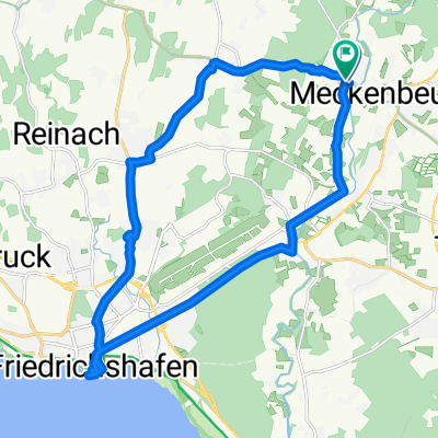
Landschaftsrunde
A cycling route starting in Meckenbeuren, Baden-Wurttemberg, Germany.
Overview
About this route
Beautiful tour through the wetlands of Oberschwaben. Relatively steep ascents between Obereschach-Furt and Siggenweiler (about 2 km), after that easy to manage, the rest of the route is quite flat. Scenically lovely, especially in Argental along the Argen.
- -:--
- Duration
- 37.2 km
- Distance
- 264 m
- Ascent
- 280 m
- Descent
- ---
- Avg. speed
- 554 m
- Max. altitude
Route quality
Waytypes & surfaces along the route
Waytypes
Road
10.8 km
(29 %)
Quiet road
9.3 km
(25 %)
Surfaces
Paved
29 km
(78 %)
Unpaved
5.2 km
(14 %)
Asphalt
27.2 km
(73 %)
Gravel
3.3 km
(9 %)
Continue with Bikemap
Use, edit, or download this cycling route
You would like to ride Landschaftsrunde or customize it for your own trip? Here is what you can do with this Bikemap route:
Free features
- Save this route as favorite or in collections
- Copy & plan your own version of this route
- Sync your route with Garmin or Wahoo
Premium features
Free trial for 3 days, or one-time payment. More about Bikemap Premium.
- Navigate this route on iOS & Android
- Export a GPX / KML file of this route
- Create your custom printout (try it for free)
- Download this route for offline navigation
Discover more Premium features.
Get Bikemap PremiumFrom our community
Other popular routes starting in Meckenbeuren
- Meckenbeuren-Runde-30
- Distance
- 31.3 km
- Ascent
- 230 m
- Descent
- 227 m
- Location
- Meckenbeuren, Baden-Wurttemberg, Germany
- Flache GA-Runde
- Distance
- 78.6 km
- Ascent
- 472 m
- Descent
- 480 m
- Location
- Meckenbeuren, Baden-Wurttemberg, Germany
- Lochbrüke-hopfengut-brochenzell
- Distance
- 21.9 km
- Ascent
- 204 m
- Descent
- 205 m
- Location
- Meckenbeuren, Baden-Wurttemberg, Germany
- Radrunde Fn
- Distance
- 22.9 km
- Ascent
- 71 m
- Descent
- 70 m
- Location
- Meckenbeuren, Baden-Wurttemberg, Germany
- Meckenbeuren - Tettnang - Ravensburg
- Distance
- 35.8 km
- Ascent
- 224 m
- Descent
- 226 m
- Location
- Meckenbeuren, Baden-Wurttemberg, Germany
- Langsame Fahrt in Meckenbeuren
- Distance
- 17 km
- Ascent
- 109 m
- Descent
- 105 m
- Location
- Meckenbeuren, Baden-Wurttemberg, Germany
- Antoniuskapelle
- Distance
- 57.3 km
- Ascent
- 376 m
- Descent
- 378 m
- Location
- Meckenbeuren, Baden-Wurttemberg, Germany
- Landschaftsrunde
- Distance
- 38.3 km
- Ascent
- 209 m
- Descent
- 210 m
- Location
- Meckenbeuren, Baden-Wurttemberg, Germany
Open it in the app