

Grey Court 2 Paris Day 2
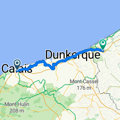
A cycling route starting in Calais, Hauts-de-France, France.
Overview
About this route
Day 2 of our route
- -:--
- Duration
- 121.9 km
- Distance
- 582 m
- Ascent
- 569 m
- Descent
- ---
- Avg. speed
- ---
- Max. altitude

Route quality
Waytypes & surfaces along the route
Waytypes
Road
59.7 km
(49 %)
Quiet road
8.5 km
(7 %)
Surfaces
Paved
57.3 km
(47 %)
Asphalt
57.3 km
(47 %)
Undefined
64.6 km
(53 %)
Route highlights
Points of interest along the route
Point of interest after 28.9 km
Rest stop 1 16 miles
Point of interest after 58.4 km
Rest stop 2 35.5 miles
Point of interest after 68.8 km
Lunch stop 42 miles
Point of interest after 98 km
Rest stop 3 60 miles
Continue with Bikemap
Use, edit, or download this cycling route
You would like to ride Grey Court 2 Paris Day 2 or customize it for your own trip? Here is what you can do with this Bikemap route:
Free features
- Save this route as favorite or in collections
- Copy & plan your own version of this route
- Split it into stages to create a multi-day tour
- Sync your route with Garmin or Wahoo
Premium features
Free trial for 3 days, or one-time payment. More about Bikemap Premium.
- Navigate this route on iOS & Android
- Export a GPX / KML file of this route
- Create your custom printout (try it for free)
- Download this route for offline navigation
Discover more Premium features.
Get Bikemap PremiumFrom our community
Other popular routes starting in Calais
 C K2 Calais - Dieppe
- Distance
- 260 km
- Ascent
- 1,578 m
- Descent
- 1,580 m
- Location
- Calais, Hauts-de-France, France
 Calais to Pauwel Heinderycxstraat, Veurne
- Distance
- 77.3 km
- Ascent
- 45 m
- Descent
- 52 m
- Location
- Calais, Hauts-de-France, France
 Au Fil de l’Eau - Étape 3 - Calais - Hardelot
- Distance
- 66.6 km
- Ascent
- 651 m
- Descent
- 634 m
- Location
- Calais, Hauts-de-France, France
 Stage 2- Calais- Bruge
- Distance
- 114 km
- Ascent
- 29 m
- Descent
- 22 m
- Location
- Calais, Hauts-de-France, France
 Calais nach Veurne
- Distance
- 79.8 km
- Ascent
- 44 m
- Descent
- 44 m
- Location
- Calais, Hauts-de-France, France
 Alpe d’Huez Trip
- Distance
- 1,072.3 km
- Ascent
- 7,329 m
- Descent
- 5,556 m
- Location
- Calais, Hauts-de-France, France
 Route #3
- Distance
- 123.6 km
- Ascent
- 0 m
- Descent
- 0 m
- Location
- Calais, Hauts-de-France, France
 Calais to the Hoek of Holland
- Distance
- 256.2 km
- Ascent
- 31 m
- Descent
- 28 m
- Location
- Calais, Hauts-de-France, France
Open it in the app