
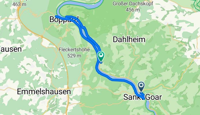
Boppard
A cycling route starting in Sankt Goar, Rhineland-Palatinate, Germany.
Overview
About this route
St. Goarshausen - Fähre - Hirzenach - Boppard - Fähre - Kamp-Bornhofen
- -:--
- Duration
- 26.8 km
- Distance
- 122 m
- Ascent
- 132 m
- Descent
- ---
- Avg. speed
- ---
- Max. altitude

Route quality
Waytypes & surfaces along the route
Waytypes
Path
14 km
(52 %)
Quiet road
3.2 km
(12 %)
Surfaces
Paved
23.6 km
(88 %)
Asphalt
23.1 km
(86 %)
Paved (undefined)
0.5 km
(2 %)
Undefined
3.2 km
(12 %)
Continue with Bikemap
Use, edit, or download this cycling route
You would like to ride Boppard or customize it for your own trip? Here is what you can do with this Bikemap route:
Free features
- Save this route as favorite or in collections
- Copy & plan your own version of this route
- Sync your route with Garmin or Wahoo
Premium features
Free trial for 3 days, or one-time payment. More about Bikemap Premium.
- Navigate this route on iOS & Android
- Export a GPX / KML file of this route
- Create your custom printout (try it for free)
- Download this route for offline navigation
Discover more Premium features.
Get Bikemap PremiumFrom our community
Other popular routes starting in Sankt Goar
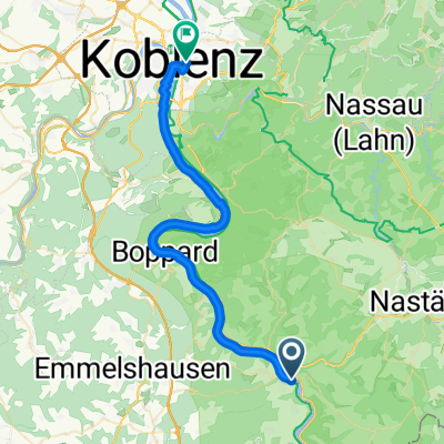 Heerstraße, Sankt Goar to Rheinsteigufer, Koblenz
- Distance
- 37.7 km
- Ascent
- 365 m
- Descent
- 384 m
- Location
- Sankt Goar, Rhineland-Palatinate, Germany
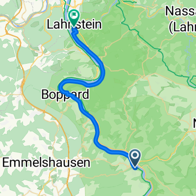 Von Sankt Goar bis Lahnstein
- Distance
- 30.1 km
- Ascent
- 243 m
- Descent
- 319 m
- Location
- Sankt Goar, Rhineland-Palatinate, Germany
 Efteling - Tag 17
- Distance
- 56.9 km
- Ascent
- 111 m
- Descent
- 172 m
- Location
- Sankt Goar, Rhineland-Palatinate, Germany
 St. Goar - Mainz
- Distance
- 59.9 km
- Ascent
- 237 m
- Descent
- 218 m
- Location
- Sankt Goar, Rhineland-Palatinate, Germany
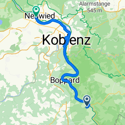
 9 S. Goar - Koblenz
- Distance
- 40.4 km
- Ascent
- 315 m
- Descent
- 422 m
- Location
- Sankt Goar, Rhineland-Palatinate, Germany
 Bahnhofstraße nach Julius-Wegeler-Straße
- Distance
- 39.7 km
- Ascent
- 108 m
- Descent
- 151 m
- Location
- Sankt Goar, Rhineland-Palatinate, Germany
 M-K: Tag 4 St. Goar/St. Goarshausen-Koblenz, 40 km
- Distance
- 40.4 km
- Ascent
- 192 m
- Descent
- 195 m
- Location
- Sankt Goar, Rhineland-Palatinate, Germany
 Heerstraße 43–47, Sankt Goar nach Wassergasse 12, Flonheim
- Distance
- 58.1 km
- Ascent
- 372 m
- Descent
- 296 m
- Location
- Sankt Goar, Rhineland-Palatinate, Germany
Open it in the app