


Freigasse 35, Geisleden to Freigasse 39, Geisleden
- 18.5 km
- 740 m
- 740 m
- Geisleden, Thuringia, Germany
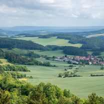
Heiligenstadt - Dieteröder Klippen
A cycling route starting in Geisleden, Thuringia, Germany.
Overview
created this 9 years ago
Part of
Heiligenstadt - Dieteröder Klippen
1 stage


Route quality
Path
7 km
(28 %)
Track
6.5 km
(26 %)
Paved
14.7 km
(59 %)
Unpaved
6.5 km
(26 %)
Asphalt
14.7 km
(59 %)
Gravel
4.5 km
(18 %)
Continue with Bikemap
You would like to ride Ausfahrt durch Heilbad Heiligenstadt nach Dieterröter Klippen or customize it for your own trip? Here is what you can do with this Bikemap route:
Free trial for 3 days, or one-time payment. More about Bikemap Premium.
Discover more Premium features.
Get Bikemap PremiumFrom our community
Open it in the app


