

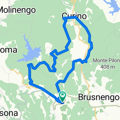
Granfondo del Bramaterra 2016 (senso ORARIO) 45km 1500hm
A cycling route starting in Masserano, Piedmont, Italy.
Overview
About this route
The route is approximately 45 km long and has an elevation gain of 1500 m. We start from the cemetery of Masserano, cross the whole town along the main street, then enter the woods from Frazione Baltera, cover a good part of the Fornera and then arrive near the dam of Lake delle Piane via a short, fun and at times steep path (BE CAREFUL to make the eye dance). After a stretch on asphalt, a first climb awaits us that is not excessively long (about 200 m) but quite demanding, at the end of which the road will have turned into a single-track that, like the previous descent, will quickly bring us in front of the gate of the Arcobaleno park (within which is our Bike Park). A quick touch-and-go of our XC route in the Bike Park Rive Rosse and then we will enter the territory of the municipality of Curino to head towards Cantone Bosi, continuing to Bugellio finally emerging between white roads and fun single-tracks behind the municipality building. After crossing the provincial road, we will proceed along the path that skirts the parish church of Curino, at the end of which we will join the unpaved road in the direction of Pianelle. From here we will start climbing towards Olzera, Colmo, then continue on the panoramic firebreak between the territories of Curino and Sostegno (we will be at the highest point of our route, about 650 m above sea level). At the end of the firebreak, from the asphalt road we will reach the municipality of Sostegno, which we will cross to head through the woods towards Villa Del Bosco. From this point we will reach, via the firebreak and paths, the Church of Madonna degli Angeli in Brusnengo passing between vineyards and hills of the red shores with suggestive panoramas. We are in the last kilometers so we head back towards Masserano which we will reach by passing through the hamlets of Rongio and Bozzonetti, one last effort awaits us, and it is the old cobbled climb which, if wet, could be quite slippery. Well, the 45 km of the 2016 route are finished, we hope they have been satisfying, enjoyable and not too demanding.
- -:--
- Duration
- 44.3 km
- Distance
- 926 m
- Ascent
- 905 m
- Descent
- ---
- Avg. speed
- ---
- Max. altitude

Continue with Bikemap
Use, edit, or download this cycling route
You would like to ride Granfondo del Bramaterra 2016 (senso ORARIO) 45km 1500hm or customize it for your own trip? Here is what you can do with this Bikemap route:
Free features
- Save this route as favorite or in collections
- Copy & plan your own version of this route
- Sync your route with Garmin or Wahoo
Premium features
Free trial for 3 days, or one-time payment. More about Bikemap Premium.
- Navigate this route on iOS & Android
- Export a GPX / KML file of this route
- Create your custom printout (try it for free)
- Download this route for offline navigation
Discover more Premium features.
Get Bikemap PremiumFrom our community
Other popular routes starting in Masserano
 Salita classica M41
- Distance
- 6.1 km
- Ascent
- 247 m
- Descent
- 62 m
- Location
- Masserano, Piedmont, Italy
 Granfondo del Bramaterra 2016 (senso ORARIO) 45km 1500hm
- Distance
- 44.3 km
- Ascent
- 926 m
- Descent
- 905 m
- Location
- Masserano, Piedmont, Italy
 GF Bramaterra 2016
- Distance
- 45.4 km
- Ascent
- 1,348 m
- Descent
- 1,298 m
- Location
- Masserano, Piedmont, Italy
 bramaterra
- Distance
- 15.7 km
- Ascent
- 417 m
- Descent
- 417 m
- Location
- Masserano, Piedmont, Italy
 Gran Fondo del Bramaterra 2016 corto
- Distance
- 15.7 km
- Ascent
- 430 m
- Descent
- 430 m
- Location
- Masserano, Piedmont, Italy
 Cammino Eusebiano - 3 tappa
- Distance
- 21.8 km
- Ascent
- 572 m
- Descent
- 443 m
- Location
- Masserano, Piedmont, Italy
Open it in the app