

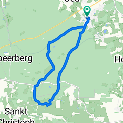
Radltour Maithenbeth - Albaching
A cycling route starting in Maitenbeth, Bavaria, Germany.
Overview
About this route
- -:--
- Duration
- 18.4 km
- Distance
- 219 m
- Ascent
- 211 m
- Descent
- ---
- Avg. speed
- 598 m
- Max. altitude
Route quality
Waytypes & surfaces along the route
Waytypes
Quiet road
13.5 km
(74 %)
Track
2.6 km
(14 %)
Surfaces
Paved
9 km
(49 %)
Unpaved
6.2 km
(34 %)
Asphalt
8.8 km
(48 %)
Gravel
4.6 km
(25 %)
Route highlights
Points of interest along the route

Photo after 4.2 km
Blick auf Albaching

Point of interest after 9.6 km
Kurz vor Holzhäuseln

Point of interest after 9.8 km
Alpenpanorama

Point of interest after 11.8 km

Point of interest after 13.7 km
Continue with Bikemap
Use, edit, or download this cycling route
You would like to ride Radltour Maithenbeth - Albaching or customize it for your own trip? Here is what you can do with this Bikemap route:
Free features
- Save this route as favorite or in collections
- Copy & plan your own version of this route
- Sync your route with Garmin or Wahoo
Premium features
Free trial for 3 days, or one-time payment. More about Bikemap Premium.
- Navigate this route on iOS & Android
- Export a GPX / KML file of this route
- Create your custom printout (try it for free)
- Download this route for offline navigation
Discover more Premium features.
Get Bikemap PremiumFrom our community
Other popular routes starting in Maitenbeth
 KesselseeRunde
- Distance
- 33.3 km
- Ascent
- 231 m
- Descent
- 231 m
- Location
- Maitenbeth, Bavaria, Germany
 Radltour Maithenbeth - Albaching
- Distance
- 18.4 km
- Ascent
- 219 m
- Descent
- 211 m
- Location
- Maitenbeth, Bavaria, Germany
 TSV Erding - Berging
- Distance
- 15.2 km
- Ascent
- 199 m
- Descent
- 199 m
- Location
- Maitenbeth, Bavaria, Germany
 wasserburg
- Distance
- 17.9 km
- Ascent
- 91 m
- Descent
- 257 m
- Location
- Maitenbeth, Bavaria, Germany
 noch eine WWW-Runde
- Distance
- 30.2 km
- Ascent
- 286 m
- Descent
- 285 m
- Location
- Maitenbeth, Bavaria, Germany
 Isen-QuelleR-23
- Distance
- 22.1 km
- Ascent
- 93 m
- Descent
- 229 m
- Location
- Maitenbeth, Bavaria, Germany
 große KlosterAu-Stampfel-Berg-Runde
- Distance
- 41.8 km
- Ascent
- 524 m
- Descent
- 534 m
- Location
- Maitenbeth, Bavaria, Germany
 Bergpanorama
- Distance
- 9.5 km
- Ascent
- 174 m
- Descent
- 171 m
- Location
- Maitenbeth, Bavaria, Germany
Open it in the app