

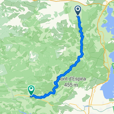
20160612_144211.gpx
A cycling route starting in Bizanet, Languedoc-Roussillon-Midi-Pyrénées, France.
Overview
About this route
TEASI track
- -:--
- Duration
- 14.6 km
- Distance
- 59 m
- Ascent
- 167 m
- Descent
- ---
- Avg. speed
- ---
- Max. altitude

Continue with Bikemap
Use, edit, or download this cycling route
You would like to ride 20160612_144211.gpx or customize it for your own trip? Here is what you can do with this Bikemap route:
Free features
- Save this route as favorite or in collections
- Copy & plan your own version of this route
- Sync your route with Garmin or Wahoo
Premium features
Free trial for 3 days, or one-time payment. More about Bikemap Premium.
- Navigate this route on iOS & Android
- Export a GPX / KML file of this route
- Create your custom printout (try it for free)
- Download this route for offline navigation
Discover more Premium features.
Get Bikemap PremiumFrom our community
Other popular routes starting in Bizanet
 narbonne plage
- Distance
- 38.4 km
- Ascent
- 89 m
- Descent
- 189 m
- Location
- Bizanet, Languedoc-Roussillon-Midi-Pyrénées, France
 1 Chemin des Gayettes, Saint-André-de-Roquelongue à 8 Route du Lac, Homps
- Distance
- 24.4 km
- Ascent
- 125 m
- Descent
- 148 m
- Location
- Bizanet, Languedoc-Roussillon-Midi-Pyrénées, France
 20160612_144211.gpx
- Distance
- 14.6 km
- Ascent
- 59 m
- Descent
- 167 m
- Location
- Bizanet, Languedoc-Roussillon-Midi-Pyrénées, France
 Chateau de St. Martin de Toques - Chateau de Fontcouvert 1. Teil
- Distance
- 19.6 km
- Ascent
- 281 m
- Descent
- 356 m
- Location
- Bizanet, Languedoc-Roussillon-Midi-Pyrénées, France
 20160227
- Distance
- 109.9 km
- Ascent
- 798 m
- Descent
- 799 m
- Location
- Bizanet, Languedoc-Roussillon-Midi-Pyrénées, France
 St André de Roquelongue - Salses-le-Château
- Distance
- 53.7 km
- Ascent
- 244 m
- Descent
- 300 m
- Location
- Bizanet, Languedoc-Roussillon-Midi-Pyrénées, France
 D224, Bizanet to La Peirière, Tuchan
- Distance
- 45.6 km
- Ascent
- 453 m
- Descent
- 412 m
- Location
- Bizanet, Languedoc-Roussillon-Midi-Pyrénées, France
 Saint André de Roquelongue - Maury
- Distance
- 61.4 km
- Ascent
- 1,276 m
- Descent
- 1,183 m
- Location
- Bizanet, Languedoc-Roussillon-Midi-Pyrénées, France
Open it in the app