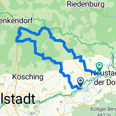
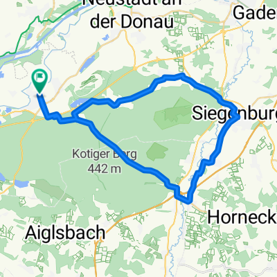
Der WEG
A cycling route starting in Münchsmünster, Bavaria, Germany.
Overview
About this route
Pförring - Ingolstadt
Ingolstadt - Pförring
- -:--
- Duration
- 22.9 km
- Distance
- 74 m
- Ascent
- 51 m
- Descent
- ---
- Avg. speed
- ---
- Max. altitude
Route quality
Waytypes & surfaces along the route
Waytypes
Path
10.2 km
(44 %)
Quiet road
5.5 km
(24 %)
Surfaces
Paved
15.4 km
(68 %)
Unpaved
2.2 km
(9 %)
Asphalt
15.1 km
(66 %)
Unpaved (undefined)
1.7 km
(7 %)
Continue with Bikemap
Use, edit, or download this cycling route
You would like to ride Der WEG or customize it for your own trip? Here is what you can do with this Bikemap route:
Free features
- Save this route as favorite or in collections
- Copy & plan your own version of this route
- Sync your route with Garmin or Wahoo
Premium features
Free trial for 3 days, or one-time payment. More about Bikemap Premium.
- Navigate this route on iOS & Android
- Export a GPX / KML file of this route
- Create your custom printout (try it for free)
- Download this route for offline navigation
Discover more Premium features.
Get Bikemap PremiumFrom our community
Other popular routes starting in Münchsmünster
- 46er Chicane 2018/2
- Distance
- 69.4 km
- Ascent
- 224 m
- Descent
- 234 m
- Location
- Münchsmünster, Bavaria, Germany
- BMW 2011-1
- Distance
- 134.7 km
- Ascent
- 900 m
- Descent
- 899 m
- Location
- Münchsmünster, Bavaria, Germany
- Münchsmünster - Siegenburg - Rundfahrt
- Distance
- 34.9 km
- Ascent
- 269 m
- Descent
- 250 m
- Location
- Münchsmünster, Bavaria, Germany
- altmühlrunde2016
- Distance
- 102 km
- Ascent
- 788 m
- Descent
- 781 m
- Location
- Münchsmünster, Bavaria, Germany
- 2025 Steinbuckelrunde
- Distance
- 58.8 km
- Ascent
- 841 m
- Descent
- 856 m
- Location
- Münchsmünster, Bavaria, Germany
- Der WEG
- Distance
- 22.9 km
- Ascent
- 74 m
- Descent
- 51 m
- Location
- Münchsmünster, Bavaria, Germany
- große CX Kapfelberg 2018
- Distance
- 100.1 km
- Ascent
- 546 m
- Descent
- 558 m
- Location
- Münchsmünster, Bavaria, Germany
- jurarunde 2014
- Distance
- 157.1 km
- Ascent
- 974 m
- Descent
- 973 m
- Location
- Münchsmünster, Bavaria, Germany
Open it in the app