

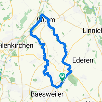
Übach - Sophienhöhe - Übach # 57km # 22.6.2016
A cycling route starting in Baesweiler, North Rhine-Westphalia, Germany.
Overview
About this route
Specialized FSR Best # Bike (-;
- -:--
- Duration
- 57.6 km
- Distance
- 305 m
- Ascent
- 304 m
- Descent
- ---
- Avg. speed
- ---
- Max. altitude

Route quality
Waytypes & surfaces along the route
Waytypes
Path
17.6 km
(31 %)
Track
11.6 km
(20 %)
Surfaces
Paved
36.9 km
(64 %)
Unpaved
11.4 km
(20 %)
Asphalt
33.4 km
(58 %)
Gravel
7 km
(12 %)
Route highlights
Points of interest along the route
Point of interest after 28 km
Foto : Römerturm
Continue with Bikemap
Use, edit, or download this cycling route
You would like to ride Übach - Sophienhöhe - Übach # 57km # 22.6.2016 or customize it for your own trip? Here is what you can do with this Bikemap route:
Free features
- Save this route as favorite or in collections
- Copy & plan your own version of this route
- Sync your route with Garmin or Wahoo
Premium features
Free trial for 3 days, or one-time payment. More about Bikemap Premium.
- Navigate this route on iOS & Android
- Export a GPX / KML file of this route
- Create your custom printout (try it for free)
- Download this route for offline navigation
Discover more Premium features.
Get Bikemap PremiumFrom our community
Other popular routes starting in Baesweiler
 Übach - Sophienhöhe - Übach # 57km # 22.6.2016
- Distance
- 57.6 km
- Ascent
- 305 m
- Descent
- 304 m
- Location
- Baesweiler, North Rhine-Westphalia, Germany
 Mit Chris um den Blausteinsee
- Distance
- 31.3 km
- Ascent
- 91 m
- Descent
- 87 m
- Location
- Baesweiler, North Rhine-Westphalia, Germany
 St Vith
- Distance
- 107.3 km
- Ascent
- 683 m
- Descent
- 360 m
- Location
- Baesweiler, North Rhine-Westphalia, Germany
 Rundweg I von Setterich
- Distance
- 27.4 km
- Ascent
- 70 m
- Descent
- 68 m
- Location
- Baesweiler, North Rhine-Westphalia, Germany
 Ca.drei Stunden
- Distance
- 72 km
- Ascent
- 475 m
- Descent
- 423 m
- Location
- Baesweiler, North Rhine-Westphalia, Germany
 2017 Adolfosee
- Distance
- 62.7 km
- Ascent
- 142 m
- Descent
- 162 m
- Location
- Baesweiler, North Rhine-Westphalia, Germany
 2017 Blausteinsee Aktifurlaub
- Distance
- 34 km
- Ascent
- 85 m
- Descent
- 101 m
- Location
- Baesweiler, North Rhine-Westphalia, Germany
 Sonntags Route
- Distance
- 24 km
- Ascent
- 81 m
- Descent
- 81 m
- Location
- Baesweiler, North Rhine-Westphalia, Germany
Open it in the app