

Sella Ronda clockwise completed (facut)
A cycling route starting in Abtei-Badia, Trentino-Alto Adige, Italy.
Overview
About this route
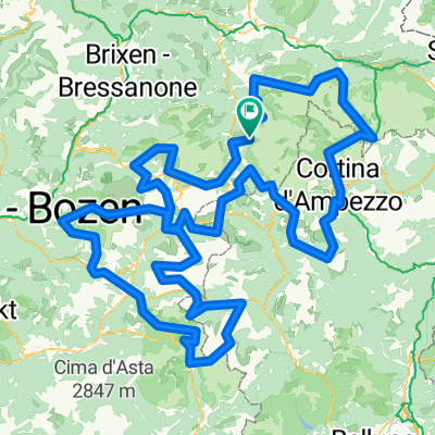
Sella Ronda clockwise completed, using all the lifts as described in their leaflets.
Starting from La Villa / Stern (and ending back in the same place);
Take the Piz la Villa elevator from La Villa. This is instead of the Col Alt from Corvara (if you start from La Villa).
Follow the trail down to Pass Campolongo. Take the Campolongo / Bec de Roces elevator.
Follow the tail down to Arabba. Take the Porta Vescovo elevator.
Go down to Pont de Vauz. Take the Fodom elevator.
Go down (partly by road) to Canazei and then to Campitello. Take the Col Rodella elevator.
Follow the trail to Selva Gardena / Wolkenstein. Take the Dantercepies line (up to the summit, do NOT go out at the intermediary station).
Go down to Corvara.
Now you have a choice of getting to La Villa by road (fast and the only option if it is past 17:30) or to go up again via Col Alt and Baia Fraida; then go down to La Villa.
Carefull: it is a LONG trail and if you stop (even a little) or pause for lunch, you will arrive later than 17:30. You will have the unpleasant surprise to discover that you cannot board the last elevator (since most of them stop at that time).
Starting at 8:30 (when the elevators start working) is A MUST.
So, you've been warned.
Otherwise, an excellent trail, with breathtaking scenery,
- -:--
- Duration
- 66.4 km
- Distance
- 3,370 m
- Ascent
- 3,369 m
- Descent
- ---
- Avg. speed
- ---
- Avg. speed

Continue with Bikemap
Use, edit, or download this cycling route
You would like to ride Sella Ronda clockwise completed (facut) or customize it for your own trip? Here is what you can do with this Bikemap route:
Free features
- Save this route as favorite or in collections
- Copy & plan your own version of this route
- Sync your route with Garmin or Wahoo
Premium features
Free trial for 3 days, or one-time payment. More about Bikemap Premium.
- Navigate this route on iOS & Android
- Export a GPX / KML file of this route
- Create your custom printout (try it for free)
- Download this route for offline navigation
Discover more Premium features.
Get Bikemap PremiumFrom our community
Other popular routes starting in Abtei-Badia
 Dolomitok 2. nap (multi)
- Distance
- 160.1 km
- Ascent
- 3,537 m
- Descent
- 3,534 m
- Location
- Abtei-Badia, Trentino-Alto Adige, Italy
 hotel-linder-neu-groeden-pralongia-hochplateau - proposed
- Distance
- 45.5 km
- Ascent
- 2,099 m
- Descent
- 2,099 m
- Location
- Abtei-Badia, Trentino-Alto Adige, Italy
 Maratona dles Dolomites 2008, mittlere Runde
- Distance
- 103 km
- Ascent
- 3,096 m
- Descent
- 2,950 m
- Location
- Abtei-Badia, Trentino-Alto Adige, Italy
 Maratona dles Dolomites
- Distance
- 137.5 km
- Ascent
- 3,883 m
- Descent
- 3,539 m
- Location
- Abtei-Badia, Trentino-Alto Adige, Italy
 Dolomites +
- Distance
- 380.4 km
- Ascent
- 11,658 m
- Descent
- 11,668 m
- Location
- Abtei-Badia, Trentino-Alto Adige, Italy
 Maratona dles Dolomites
- Distance
- 138 km
- Ascent
- 5,099 m
- Descent
- 4,822 m
- Location
- Abtei-Badia, Trentino-Alto Adige, Italy
 Medalges
- Distance
- 51.8 km
- Ascent
- 2,005 m
- Descent
- 2,003 m
- Location
- Abtei-Badia, Trentino-Alto Adige, Italy
 St. Kassian-Armentarola-Störes-Corvara-St. Kassian
- Distance
- 23.2 km
- Ascent
- 822 m
- Descent
- 827 m
- Location
- Abtei-Badia, Trentino-Alto Adige, Italy
Open it in the app