
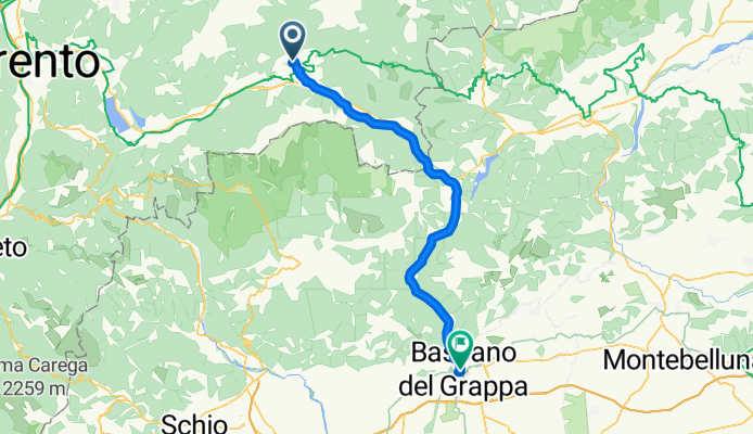
Route3-1
A cycling route starting in Carzano, Trentino-Alto Adige, Italy.
Overview
About this route
- -:--
- Duration
- 51.6 km
- Distance
- 266 m
- Ascent
- 583 m
- Descent
- ---
- Avg. speed
- ---
- Max. altitude
Continue with Bikemap
Use, edit, or download this cycling route
You would like to ride Route3-1 or customize it for your own trip? Here is what you can do with this Bikemap route:
Free features
- Save this route as favorite or in collections
- Copy & plan your own version of this route
- Sync your route with Garmin or Wahoo
Premium features
Free trial for 3 days, or one-time payment. More about Bikemap Premium.
- Navigate this route on iOS & Android
- Export a GPX / KML file of this route
- Create your custom printout (try it for free)
- Download this route for offline navigation
Discover more Premium features.
Get Bikemap PremiumFrom our community
Other popular routes starting in Carzano
 3Carzano-Vigodazere
- Distance
- 107.9 km
- Ascent
- 98 m
- Descent
- 515 m
- Location
- Carzano, Trentino-Alto Adige, Italy
 Route3-1
- Distance
- 51.6 km
- Ascent
- 266 m
- Descent
- 583 m
- Location
- Carzano, Trentino-Alto Adige, Italy
 Vicenca
- Distance
- 110.9 km
- Ascent
- 68 m
- Descent
- 478 m
- Location
- Carzano, Trentino-Alto Adige, Italy
 Borgo Valsugana - Forte Busa Runde (63 km)
- Distance
- 61.5 km
- Ascent
- 2,381 m
- Descent
- 2,394 m
- Location
- Carzano, Trentino-Alto Adige, Italy
 Alpen Tag 5 Chioggia
- Distance
- 159 km
- Ascent
- 614 m
- Descent
- 1,060 m
- Location
- Carzano, Trentino-Alto Adige, Italy
 3Carzano-Vicenza
- Distance
- 94 km
- Ascent
- 170 m
- Descent
- 484 m
- Location
- Carzano, Trentino-Alto Adige, Italy
 Carzano Manghenpass
- Distance
- 23.2 km
- Ascent
- 1,591 m
- Descent
- 128 m
- Location
- Carzano, Trentino-Alto Adige, Italy
 Carzano- Forte Leone - Arsiè Runde (89 km)
- Distance
- 86.8 km
- Ascent
- 3,246 m
- Descent
- 3,243 m
- Location
- Carzano, Trentino-Alto Adige, Italy
Open it in the app