

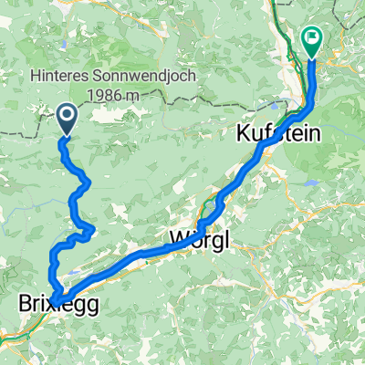
Erzherzog-Johann-Klause_Röhrlmoosalm
A cycling route starting in Brandenberg, Tyrol, Austria.
Overview
About this route
The route was drawn on 'bikemap'. In the meantime, I rode it. Highly recommended!
- -:--
- Duration
- 24.8 km
- Distance
- 672 m
- Ascent
- 368 m
- Descent
- ---
- Avg. speed
- ---
- Max. altitude

Route highlights
Points of interest along the route
Point of interest after 0 km
Erzherzog-Johann-Klause (47.581389,11.888087)
Point of interest after 6.1 km
Jocher Baieralm (47.592591,11.830044)
Point of interest after 14.1 km
Schwaiger Alm (47.628004,11.758032)
Point of interest after 24.8 km
Röhrlmoosalm (47.597236,11.608729)
Continue with Bikemap
Use, edit, or download this cycling route
You would like to ride Erzherzog-Johann-Klause_Röhrlmoosalm or customize it for your own trip? Here is what you can do with this Bikemap route:
Free features
- Save this route as favorite or in collections
- Copy & plan your own version of this route
- Sync your route with Garmin or Wahoo
Premium features
Free trial for 3 days, or one-time payment. More about Bikemap Premium.
- Navigate this route on iOS & Android
- Export a GPX / KML file of this route
- Create your custom printout (try it for free)
- Download this route for offline navigation
Discover more Premium features.
Get Bikemap PremiumFrom our community
Other popular routes starting in Brandenberg
 1983_OBTI_T3_Erzherzog-Johann-Klause_Niederndorf
- Distance
- 67.7 km
- Ascent
- 353 m
- Descent
- 672 m
- Location
- Brandenberg, Tyrol, Austria
 Erzherzog-Johann-Klause_Röhrlmoosalm
- Distance
- 24.8 km
- Ascent
- 672 m
- Descent
- 368 m
- Location
- Brandenberg, Tyrol, Austria
 Challenge 117
- Distance
- 117.4 km
- Ascent
- 982 m
- Descent
- 982 m
- Location
- Brandenberg, Tyrol, Austria
 Brandenberg - Hopfgarten (Brixental)
- Distance
- 42.6 km
- Ascent
- 873 m
- Descent
- 1,000 m
- Location
- Brandenberg, Tyrol, Austria
 Steinberg
- Distance
- 26.1 km
- Ascent
- 921 m
- Descent
- 921 m
- Location
- Brandenberg, Tyrol, Austria
 reibaclub tour09 Tag1
- Distance
- 46 km
- Ascent
- 1,124 m
- Descent
- 1,033 m
- Location
- Brandenberg, Tyrol, Austria
 Steinberg
- Distance
- 26.2 km
- Ascent
- 942 m
- Descent
- 942 m
- Location
- Brandenberg, Tyrol, Austria
 Aschaurunde
- Distance
- 25.4 km
- Ascent
- 675 m
- Descent
- 675 m
- Location
- Brandenberg, Tyrol, Austria
Open it in the app