

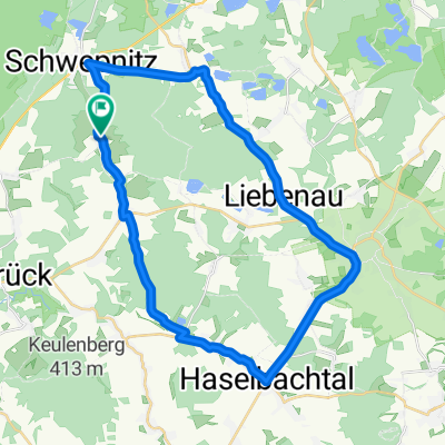
Südlich vom Senftenberger See
A cycling route starting in Schwepnitz, Saxony, Germany.
Overview
About this route
South of Senftenberg Lake: Grüngräbchen, Sella, Hohenbocka, Hosena, Peickwitz, Niemtsch, Biehlen, Schwarzbachm, Sorgenteich, Guteborn, Lipsa, Cosel, Grüngräbchen
- -:--
- Duration
- 45.3 km
- Distance
- 115 m
- Ascent
- 115 m
- Descent
- ---
- Avg. speed
- ---
- Max. altitude

Route quality
Waytypes & surfaces along the route
Waytypes
Track
27.2 km
(60 %)
Quiet road
6.3 km
(14 %)
Surfaces
Paved
31.7 km
(70 %)
Unpaved
9.5 km
(21 %)
Asphalt
23.6 km
(52 %)
Paved (undefined)
8.2 km
(18 %)
Continue with Bikemap
Use, edit, or download this cycling route
You would like to ride Südlich vom Senftenberger See or customize it for your own trip? Here is what you can do with this Bikemap route:
Free features
- Save this route as favorite or in collections
- Copy & plan your own version of this route
- Sync your route with Garmin or Wahoo
Premium features
Free trial for 3 days, or one-time payment. More about Bikemap Premium.
- Navigate this route on iOS & Android
- Export a GPX / KML file of this route
- Create your custom printout (try it for free)
- Download this route for offline navigation
Discover more Premium features.
Get Bikemap PremiumFrom our community
Other popular routes starting in Schwepnitz
 2009 Frosch Radweg--Schwepnitz bis Spremberg/Spree CLONED FROM ROUTE 304943
- Distance
- 66.1 km
- Ascent
- 129 m
- Descent
- 177 m
- Location
- Schwepnitz, Saxony, Germany
 Kurze Trainingsrunde
- Distance
- 29.5 km
- Ascent
- 181 m
- Descent
- 183 m
- Location
- Schwepnitz, Saxony, Germany
 Kleine Trainingsrunde
- Distance
- 33.1 km
- Ascent
- 239 m
- Descent
- 237 m
- Location
- Schwepnitz, Saxony, Germany
 Hoshis Longrun
- Distance
- 135.6 km
- Ascent
- 229 m
- Descent
- 229 m
- Location
- Schwepnitz, Saxony, Germany
 Schulstraße, Schwepnitz nach Oststraße 55, Schwepnitz
- Distance
- 30.4 km
- Ascent
- 485 m
- Descent
- 476 m
- Location
- Schwepnitz, Saxony, Germany
 Schulstraße 2, Schwepnitz nach Schulstraße 2, Schwepnitz
- Distance
- 32.7 km
- Ascent
- 534 m
- Descent
- 551 m
- Location
- Schwepnitz, Saxony, Germany
 Schwepnitz - Wittichenau - Boxberg (Tag 1 von 4)
- Distance
- 62.1 km
- Ascent
- 180 m
- Descent
- 193 m
- Location
- Schwepnitz, Saxony, Germany
 2009 Frosch Radweg--Schwepnitz bis Spremberg/Spree
- Distance
- 66 km
- Ascent
- 144 m
- Descent
- 182 m
- Location
- Schwepnitz, Saxony, Germany
Open it in the app