

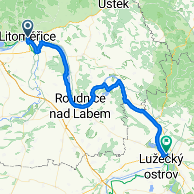
2. Litoměřice - Radejčín - Most (autodrom - 1. časovka)
A cycling route starting in Litoměřice, Ústecký kraj, Czechia.
Overview
About this route
Complicated route because it has to go through Radejčín and is mercilessly interwoven with prohibited sections. Between Most and Bílina there is a PROHIBITED SECTION (Teplice - Most - I/13) that we must avoid.
From Litoměřice: The route goes via Terezínská, Polní streets. Then along the E55 towards Bílinka, Velemín, Bílý Újezd via Hrušovka, Kletečná to Radejčín (where the newly opened tunnels are). However, here the problem is that the short section from Lovosice to Velemín is also PROHIBITED - see manual. To make matters worse, the I/30 from Lovosice is also prohibited. In Bílinka you can turn towards Oparno and continue to Chotiměř, but I did not get street view there and who knows what the road is like around Lovoš (570 m above sea level). It is also possible to go from Lovosice next to the I/30 to Malé Žernoseky.
From Radejčín: to Habrovany, Řehlovice, Brozánky, Rtyně nad Bílinou, Žalany, Bžany, Ohníč, Hostomice, Chotějovice (bypass the I/13 already in Chotějovice via Revoluční street and avoid it on the right), Bílina, Kaňkov, Braňany, Střimice - Most. In Most take Hřbitovní street over the bridge to W.A. Mozart, Jar. Seifert, left on Čs. armády, right on Partyzánská, then right on SNP street over Hořanská road to the autodrom.
- -:--
- Duration
- 60.8 km
- Distance
- 746 m
- Ascent
- 629 m
- Descent
- ---
- Avg. speed
- ---
- Max. altitude

Route photos
\"")
\"")
\"")
\"")
\"")
\"")
\"")
\"")
Route quality
Waytypes & surfaces along the route
Waytypes
Road
37.1 km
(61 %)
Quiet road
3.6 km
(6 %)
Surfaces
Paved
18.2 km
(30 %)
Asphalt
17 km
(28 %)
Paved (undefined)
1.2 km
(2 %)
Undefined
42.6 km
(70 %)
Continue with Bikemap
Use, edit, or download this cycling route
You would like to ride 2. Litoměřice - Radejčín - Most (autodrom - 1. časovka) or customize it for your own trip? Here is what you can do with this Bikemap route:
Free features
- Save this route as favorite or in collections
- Copy & plan your own version of this route
- Sync your route with Garmin or Wahoo
Premium features
Free trial for 3 days, or one-time payment. More about Bikemap Premium.
- Navigate this route on iOS & Android
- Export a GPX / KML file of this route
- Create your custom printout (try it for free)
- Download this route for offline navigation
Discover more Premium features.
Get Bikemap PremiumFrom our community
Other popular routes starting in Litoměřice
 lehká roudnická
- Distance
- 45.6 km
- Ascent
- 151 m
- Descent
- 148 m
- Location
- Litoměřice, Ústecký kraj, Czechia
 Litomerice to Decin
- Distance
- 51.1 km
- Ascent
- 273 m
- Descent
- 310 m
- Location
- Litoměřice, Ústecký kraj, Czechia
 Tschechien nach náměstí Míru
- Distance
- 51.5 km
- Ascent
- 213 m
- Descent
- 163 m
- Location
- Litoměřice, Ústecký kraj, Czechia
 Litomrice - Melnik
- Distance
- 46.8 km
- Ascent
- 145 m
- Descent
- 126 m
- Location
- Litoměřice, Ústecký kraj, Czechia
 Vrchlického, Litoměřice to Hauptstraße, Bad Schandau
- Distance
- 65.2 km
- Ascent
- 977 m
- Descent
- 966 m
- Location
- Litoměřice, Ústecký kraj, Czechia
 Litomerice to Roudnice Castle
- Distance
- 23.1 km
- Ascent
- 88 m
- Descent
- 74 m
- Location
- Litoměřice, Ústecký kraj, Czechia
 Házmburk a Libochovice
- Distance
- 50.9 km
- Ascent
- 288 m
- Descent
- 288 m
- Location
- Litoměřice, Ústecký kraj, Czechia
 Labská nach U Starého mostu
- Distance
- 49.8 km
- Ascent
- 249 m
- Descent
- 270 m
- Location
- Litoměřice, Ústecký kraj, Czechia
Open it in the app