08_Tain-Lairg_2016-06-26
A cycling route starting in Tain, Scotland, United Kingdom.
Overview
About this route
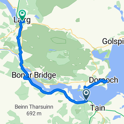
Day 8 - Tain to Lairg - 64km
- -:--
- Duration
- 63.6 km
- Distance
- 255 m
- Ascent
- 168 m
- Descent
- ---
- Avg. speed
- ---
- Avg. speed
Route quality
Waytypes & surfaces along the route
Waytypes
Busy road
31.3 km
(49 %)
Quiet road
22.2 km
(35 %)
Surfaces
Paved
22.2 km
(35 %)
Asphalt
22.2 km
(35 %)
Undefined
41.4 km
(65 %)
Route highlights
Points of interest along the route
Point of interest after 1 km
view
Point of interest after 11.2 km
beach
Point of interest after 50.3 km
track
Point of interest after 50.6 km
Track + stairs
Point of interest after 56.2 km
river
Point of interest after 59 km
bridge
Continue with Bikemap
Use, edit, or download this cycling route
You would like to ride 08_Tain-Lairg_2016-06-26 or customize it for your own trip? Here is what you can do with this Bikemap route:
Free features
- Save this route as favorite or in collections
- Copy & plan your own version of this route
- Sync your route with Garmin or Wahoo
Premium features
Free trial for 3 days, or one-time payment. More about Bikemap Premium.
- Navigate this route on iOS & Android
- Export a GPX / KML file of this route
- Create your custom printout (try it for free)
- Download this route for offline navigation
Discover more Premium features.
Get Bikemap PremiumFrom our community
Other popular routes starting in Tain
- Alness to Tain pilgrim route
- Distance
- 9.4 km
- Ascent
- 55 m
- Descent
- 126 m
- Location
- Tain, Scotland, United Kingdom
- Day 2 Houghton Riders actual Jogle Tain to Spean Bridge (Fort William)
- Distance
- 145.9 km
- Ascent
- 717 m
- Descent
- 598 m
- Location
- Tain, Scotland, United Kingdom
- D3New
- Distance
- 148.5 km
- Ascent
- 945 m
- Descent
- 762 m
- Location
- Tain, Scotland, United Kingdom
- Jog2LE Day Two
- Distance
- 140.2 km
- Ascent
- 669 m
- Descent
- 633 m
- Location
- Tain, Scotland, United Kingdom
- Scotland Day 3
- Distance
- 162.7 km
- Ascent
- 932 m
- Descent
- 756 m
- Location
- Tain, Scotland, United Kingdom
- Morangie Forest circular
- Distance
- 19.8 km
- Ascent
- 243 m
- Descent
- 243 m
- Location
- Tain, Scotland, United Kingdom
- 08_Tain-Lairg_2016-06-26
- Distance
- 63.6 km
- Ascent
- 255 m
- Descent
- 168 m
- Location
- Tain, Scotland, United Kingdom
- periple 11 / 24
- Distance
- 125.7 km
- Ascent
- 754 m
- Descent
- 683 m
- Location
- Tain, Scotland, United Kingdom
Open it in the app