

Kingussie, Newtonmore Wild Cat trail and Loch Gynack
A cycling route starting in Kingussie, Scotland, United Kingdom.
Overview
About this route
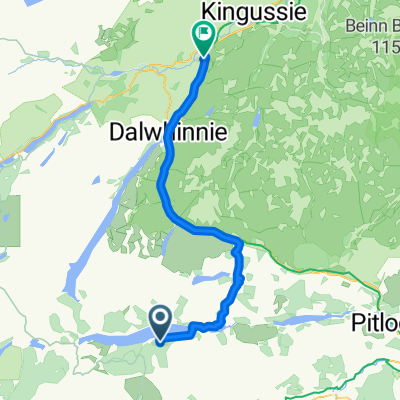
This is a medium length route of 16km / 10 miles suitable for mountain bikes. Some sections are on tarmac and estate tracks but others are on rough paths and for one section the bike will need to be lifted over a number of fences. Allow 2 hours. Ordinance Survey sheet 35 Kingussie and Monadliath Mountains. Refreshments: Cafes and bars in Kingussie and Newtonmore. Start in the centre of Kingussie and take the dedicated cycle track to Newtonmore. Turn right up the Glen Road in Newtonmore town centre and follow this quiet road until you reach a signpost for the Wildcat trail on your right. Follow the Wildcat Trail waymarks through light woodland and sheep fields where the terrain is rough in places. The bike will need to be lifted over a number of styles and fences on this stretch (it may be easier to divert and cycle down the adjacent field). When the trail emerges out onto open countryside take an estate track a few meters to the right and then almost immediately turn left and uphill alongside a small burn. This estate track narrows to single track after a while but continue to follow it until you come to a gate and a green waymark pointing right to Kingussie. The surface is better here and leads along the edge of a conifer forest until you reach a bridge over a burn and a large estate gate to the left. Go through this gate and follow the wide track uphill and through a 2nd gate. Turn right here and follow this well surfaced estate track along the northside of the scenic Loch Gynack. When you reach the far side of the Loch follow the way marks for Kingussie. After crossing the newly reinstated bridge over the Gynack (the previous bridge was washed away by the tail of Hurricane Bertha in August 2014!) it is then all downhill on a quiet smooth tarmac road back down to Kingussie.
Cycle Friendly Kingussie
- -:--
- Duration
- 16 km
- Distance
- 219 m
- Ascent
- 219 m
- Descent
- ---
- Avg. speed
- ---
- Max. altitude

Route quality
Waytypes & surfaces along the route
Waytypes
Quiet road
3.8 km
(24 %)
Track
3.7 km
(23 %)
Surfaces
Paved
8.3 km
(52 %)
Unpaved
6.1 km
(38 %)
Asphalt
7.4 km
(46 %)
Gravel
4 km
(25 %)
Route highlights
Points of interest along the route

Point of interest after 0 km
Kingussie High Street

Point of interest after 5.4 km
Glen Road Newtonmore

Point of interest after 6.2 km
Right onto the Wild Cat trail

Point of interest after 8.1 km
track to Kingussie

Point of interest after 9.6 km
Gate

Point of interest after 11.2 km
View over Loch Gynack
Continue with Bikemap
Use, edit, or download this cycling route
You would like to ride Kingussie, Newtonmore Wild Cat trail and Loch Gynack or customize it for your own trip? Here is what you can do with this Bikemap route:
Free features
- Save this route as favorite or in collections
- Copy & plan your own version of this route
- Sync your route with Garmin or Wahoo
Premium features
Free trial for 3 days, or one-time payment. More about Bikemap Premium.
- Navigate this route on iOS & Android
- Export a GPX / KML file of this route
- Create your custom printout (try it for free)
- Download this route for offline navigation
Discover more Premium features.
Get Bikemap PremiumFrom our community
Other popular routes starting in Kingussie
 Inshriach Circular
- Distance
- 25.6 km
- Ascent
- 330 m
- Descent
- 329 m
- Location
- Kingussie, Scotland, United Kingdom
 From Crubenberg to Carrbridge
- Distance
- 57.2 km
- Ascent
- 394 m
- Descent
- 436 m
- Location
- Kingussie, Scotland, United Kingdom
 Loch Rannoch to Invernahavon
- Distance
- 59.7 km
- Ascent
- 614 m
- Descent
- 587 m
- Location
- Kingussie, Scotland, United Kingdom
 Newtonmore to Auchnahillin CS nr Moy
- Distance
- 76.5 km
- Ascent
- 344 m
- Descent
- 348 m
- Location
- Kingussie, Scotland, United Kingdom
 Kingussie to FeshieBridge 2
- Distance
- 27.6 km
- Ascent
- 235 m
- Descent
- 235 m
- Location
- Kingussie, Scotland, United Kingdom
 Kingussie, Newtonmore Wild Cat trail and Loch Gynack
- Distance
- 16 km
- Ascent
- 219 m
- Descent
- 219 m
- Location
- Kingussie, Scotland, United Kingdom
 Kingussie/Inverness via Corrieyairack
- Distance
- 104.2 km
- Ascent
- 960 m
- Descent
- 1,177 m
- Location
- Kingussie, Scotland, United Kingdom
 Von Kingussie Versuch nach Fort Augustus
- Distance
- 47.4 km
- Ascent
- 644 m
- Descent
- 531 m
- Location
- Kingussie, Scotland, United Kingdom
Open it in the app