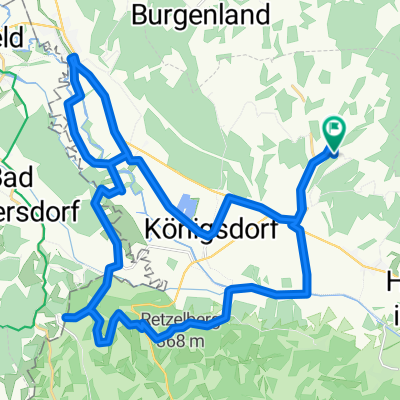
Thermenrunde
A cycling route starting in Eltendorf, Burgenland, Austria.
Overview
About this route
Über die Mühlenfahrt nach Loipersdorf und Henndorf, von dort aus über die Lafnitz nach Eltendorf und Königsdorf.
- 2 h 36 min
- Duration
- 37.1 km
- Distance
- 217 m
- Ascent
- 217 m
- Descent
- 14.3 km/h
- Avg. speed
- ---
- Avg. speed
Route quality
Waytypes & surfaces along the route
Waytypes
Quiet road
22.1 km
(60 %)
Track
8.8 km
(24 %)
Surfaces
Paved
29.7 km
(80 %)
Unpaved
3.7 km
(10 %)
Asphalt
27.2 km
(73 %)
Paved (undefined)
2.5 km
(7 %)
Route highlights
Points of interest along the route
Point of interest after 9 km
ich liebe es!
Point of interest after 9 km
toller ausblick
Point of interest after 11.4 km
*.*
Point of interest after 11.4 km
wow
Point of interest after 14.3 km
ziel erreicht - ab jetzt retour!
Point of interest after 24.7 km
Lafnitz
Continue with Bikemap
Use, edit, or download this cycling route
You would like to ride Thermenrunde or customize it for your own trip? Here is what you can do with this Bikemap route:
Free features
- Save this route as favorite or in collections
- Copy & plan your own version of this route
- Sync your route with Garmin or Wahoo
Premium features
Free trial for 3 days, or one-time payment. More about Bikemap Premium.
- Navigate this route on iOS & Android
- Export a GPX / KML file of this route
- Create your custom printout (try it for free)
- Download this route for offline navigation
Discover more Premium features.
Get Bikemap PremiumFrom our community
Other popular routes starting in Eltendorf
- Über die Hügel Kukmirns
- Distance
- 29.4 km
- Ascent
- 354 m
- Descent
- 354 m
- Location
- Eltendorf, Burgenland, Austria
- Waldrunde
- Distance
- 10.7 km
- Ascent
- 115 m
- Descent
- 115 m
- Location
- Eltendorf, Burgenland, Austria
- Südburgenländisches Uhudlerhügelfahren, Bademöglichkeit bei Lafnitz
- Distance
- 19.6 km
- Ascent
- 141 m
- Descent
- 140 m
- Location
- Eltendorf, Burgenland, Austria
- Ausschnitte des B72 Radfahrweges - über den Haarberg zur Lafnitz
- Distance
- 18.1 km
- Ascent
- 150 m
- Descent
- 150 m
- Location
- Eltendorf, Burgenland, Austria
- Große Bergrunde
- Distance
- 14.3 km
- Ascent
- 202 m
- Descent
- 202 m
- Location
- Eltendorf, Burgenland, Austria
- Über Loipersdorf nach Stein und Eltendorf
- Distance
- 34.4 km
- Ascent
- 219 m
- Descent
- 219 m
- Location
- Eltendorf, Burgenland, Austria
- 4-Täler-Runde
- Distance
- 62 km
- Ascent
- 350 m
- Descent
- 353 m
- Location
- Eltendorf, Burgenland, Austria
- Thermenrunde
- Distance
- 37.1 km
- Ascent
- 217 m
- Descent
- 217 m
- Location
- Eltendorf, Burgenland, Austria
Open it in the app