Sierra de las cabras
A cycling route starting in Nerpio, Castille-La Mancha, Spain.
Overview
About this route
El Sabinar - Nerpio - Sierra de las Cabras - Cañada de la Cruz - Barranda - Archivel - El Sabinar
- -:--
- Duration
- 118.3 km
- Distance
- 1,242 m
- Ascent
- 1,242 m
- Descent
- ---
- Avg. speed
- ---
- Max. altitude
Route quality
Waytypes & surfaces along the route
Waytypes
Busy road
54.8 km
(46 %)
Quiet road
40.1 km
(34 %)
Surfaces
Paved
108.6 km
(92 %)
Unpaved
3.6 km
(3 %)
Asphalt
108 km
(91 %)
Gravel
2.2 km
(2 %)
Continue with Bikemap
Use, edit, or download this cycling route
You would like to ride Sierra de las cabras or customize it for your own trip? Here is what you can do with this Bikemap route:
Free features
- Save this route as favorite or in collections
- Copy & plan your own version of this route
- Split it into stages to create a multi-day tour
- Sync your route with Garmin or Wahoo
Premium features
Free trial for 3 days, or one-time payment. More about Bikemap Premium.
- Navigate this route on iOS & Android
- Export a GPX / KML file of this route
- Create your custom printout (try it for free)
- Download this route for offline navigation
Discover more Premium features.
Get Bikemap PremiumFrom our community
Other popular routes starting in Nerpio
- Nº20 Sabinar-Vizcable-Benizar Titoabuelito
- Distance
- 93.3 km
- Ascent
- 1,048 m
- Descent
- 1,050 m
- Location
- Nerpio, Castille-La Mancha, Spain
- 2. Miller_Beas de Segura
- Distance
- 73.1 km
- Ascent
- 1,708 m
- Descent
- 2,037 m
- Location
- Nerpio, Castille-La Mancha, Spain
- Nº38a El Sabinar Vizcable Benizar Titoabuelito.com
- Distance
- 82.7 km
- Ascent
- 1,712 m
- Descent
- 1,703 m
- Location
- Nerpio, Castille-La Mancha, Spain
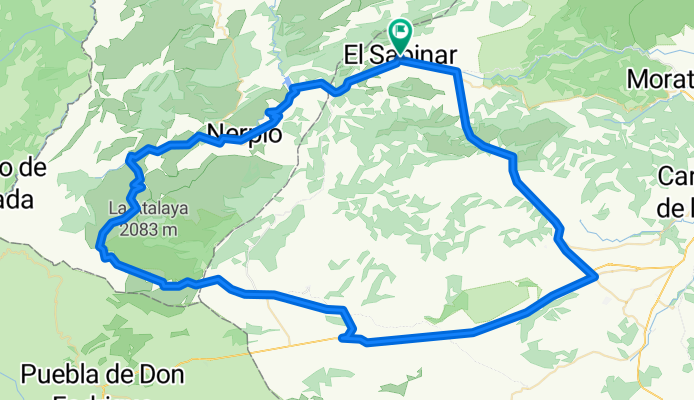
- Vuelta a la sierra de Las Cabras. Nerpio
- Distance
- 57.2 km
- Ascent
- 1,574 m
- Descent
- 1,380 m
- Location
- Nerpio, Castille-La Mancha, Spain
- Gontar - Yeste - Nerpio - Gontar
- Distance
- 128.4 km
- Ascent
- 1,786 m
- Descent
- 1,792 m
- Location
- Nerpio, Castille-La Mancha, Spain
- Sierra de las cabras
- Distance
- 118.3 km
- Ascent
- 1,242 m
- Descent
- 1,242 m
- Location
- Nerpio, Castille-La Mancha, Spain
- NerpioCoy
- Distance
- 87 km
- Ascent
- 951 m
- Descent
- 1,221 m
- Location
- Nerpio, Castille-La Mancha, Spain
- Nº61b El Sabinar, Benizar, Socovos, Letur F Sabina, El Sabinar, Titoabuelito
- Distance
- 71.8 km
- Ascent
- 897 m
- Descent
- 906 m
- Location
- Nerpio, Castille-La Mancha, Spain
Open it in the app