

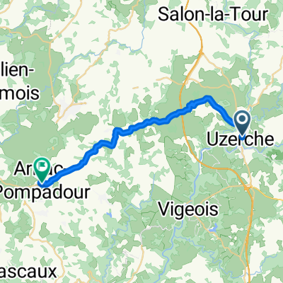
90 pompadour
A cycling route starting in Uzerche, Nouvelle-Aquitaine, France.
Overview
About this route
- -:--
- Duration
- 90.7 km
- Distance
- 886 m
- Ascent
- 885 m
- Descent
- ---
- Avg. speed
- ---
- Max. altitude
Route quality
Waytypes & surfaces along the route
Waytypes
Road
28.1 km
(31 %)
Quiet road
19.9 km
(22 %)
Surfaces
Paved
26.3 km
(29 %)
Paved (undefined)
13.6 km
(15 %)
Asphalt
12.7 km
(14 %)
Undefined
64.4 km
(71 %)
Continue with Bikemap
Use, edit, or download this cycling route
You would like to ride 90 pompadour or customize it for your own trip? Here is what you can do with this Bikemap route:
Free features
- Save this route as favorite or in collections
- Copy & plan your own version of this route
- Split it into stages to create a multi-day tour
- Sync your route with Garmin or Wahoo
Premium features
Free trial for 3 days, or one-time payment. More about Bikemap Premium.
- Navigate this route on iOS & Android
- Export a GPX / KML file of this route
- Create your custom printout (try it for free)
- Download this route for offline navigation
Discover more Premium features.
Get Bikemap PremiumFrom our community
Other popular routes starting in Uzerche
 De Rue des Fontaines 33, Saint-Ybard à Rue des Fontaines 33, Saint-Ybard
- Distance
- 15.9 km
- Ascent
- 27 m
- Descent
- 170 m
- Location
- Uzerche, Nouvelle-Aquitaine, France
 Tour Allassac Le Saillant
- Distance
- 59.3 km
- Ascent
- 713 m
- Descent
- 699 m
- Location
- Uzerche, Nouvelle-Aquitaine, France
 De 1135 Route de Jandilloux, Saint-Martin-Sepert à 2 Allée de la Papeterie, Uzerche
- Distance
- 27.4 km
- Ascent
- 365 m
- Descent
- 549 m
- Location
- Uzerche, Nouvelle-Aquitaine, France
 De Rue des Fontaines 33, Saint-Ybard à Rue des Fontaines 33, Saint-Ybard
- Distance
- 15.6 km
- Ascent
- 40 m
- Descent
- 258 m
- Location
- Uzerche, Nouvelle-Aquitaine, France
 De Avenue du Gén de Gaulle 34, Uzerche à Place du Château 1 Bis, Arnac-Pompadour
- Distance
- 21.2 km
- Ascent
- 506 m
- Descent
- 367 m
- Location
- Uzerche, Nouvelle-Aquitaine, France
 De Les Carderies, Uzerche à Les Carderies, Uzerche
- Distance
- 27.4 km
- Ascent
- 399 m
- Descent
- 394 m
- Location
- Uzerche, Nouvelle-Aquitaine, France
 De Rue des Fontaines 33, Saint-Ybard à Rue des Fontaines 33, Saint-Ybard
- Distance
- 10.8 km
- Ascent
- 9 m
- Descent
- 160 m
- Location
- Uzerche, Nouvelle-Aquitaine, France
 Tour table orientation
- Distance
- 77.8 km
- Ascent
- 862 m
- Descent
- 862 m
- Location
- Uzerche, Nouvelle-Aquitaine, France
Open it in the app