- 9.5 km
- 145 m
- 180 m
- Langenbernsdorf, Saxony, Germany
Vom Werdauer Wald zur Kober
A cycling route starting in Langenbernsdorf, Saxony, Germany.
Overview
About this route
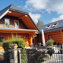
Beautiful round with a detour to the Koberbach dam, through the Werdau Forest into Thuringia's Waldhaus. A crowning finish could be a great forest sports field, or a fine beer at the Weidmannsruh, or a swim in the retention pond. Wonderful paths, some paved, but also slab paths or gravel tracks, something for everyone.
- -:--
- Duration
- 40.1 km
- Distance
- 386 m
- Ascent
- 382 m
- Descent
- ---
- Avg. speed
- 423 m
- Max. altitude
created this 17 years ago
Route quality
Waytypes & surfaces along the route
Waytypes
Track
22.9 km
(57 %)
Road
8 km
(20 %)
Surfaces
Paved
16 km
(40 %)
Unpaved
17.2 km
(43 %)
Asphalt
12 km
(30 %)
Gravel
9.6 km
(24 %)
Continue with Bikemap
Use, edit, or download this cycling route
You would like to ride Vom Werdauer Wald zur Kober or customize it for your own trip? Here is what you can do with this Bikemap route:
Free features
- Save this route as favorite or in collections
- Copy & plan your own version of this route
- Sync your route with Garmin or Wahoo
Premium features
Free trial for 3 days, or one-time payment. More about Bikemap Premium.
- Navigate this route on iOS & Android
- Export a GPX / KML file of this route
- Create your custom printout (try it for free)
- Download this route for offline navigation
Discover more Premium features.
Get Bikemap PremiumFrom our community
Other popular routes starting in Langenbernsdorf
- Hohe Straße 41E, Langenbernsdorf nach Leubnitzer Hauptstraße 25, Werdau
- Route nach Werdau
- 18.9 km
- 113 m
- 111 m
- Langenbernsdorf, Saxony, Germany
- waldrunde
- 11.5 km
- 140 m
- 104 m
- Langenbernsdorf, Saxony, Germany
- Hauptstraße nach Crimmitschauer Straße
- 3.9 km
- 0 m
- 68 m
- Langenbernsdorf, Saxony, Germany
- Langenbernsdorf - Bad Elster
- 67.7 km
- 1,260 m
- 954 m
- Langenbernsdorf, Saxony, Germany
- Waldperle Waldsportplatz Waldperle
- 8.5 km
- 127 m
- 127 m
- Langenbernsdorf, Saxony, Germany
- Bahnhofstraße nach Bahnhofstraße
- 25.4 km
- 338 m
- 378 m
- Langenbernsdorf, Saxony, Germany
- Vom Werdauer Wald zur Kober
- 40.1 km
- 386 m
- 382 m
- Langenbernsdorf, Saxony, Germany
Open it in the app


