

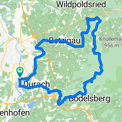
Runde um den Rottachspeicher
A cycling route starting in Durach, Bavaria, Germany.
Overview
About this route
Sulzberg - Rettenberg - Petersthal - Oberzollhaus - Durach
- -:--
- Duration
- 56.4 km
- Distance
- 493 m
- Ascent
- 488 m
- Descent
- ---
- Avg. speed
- ---
- Max. altitude

Route quality
Waytypes & surfaces along the route
Waytypes
Road
27.7 km
(49 %)
Quiet road
18.1 km
(32 %)
Surfaces
Paved
48.5 km
(86 %)
Unpaved
0.6 km
(1 %)
Asphalt
48.5 km
(86 %)
Gravel
0.6 km
(1 %)
Undefined
7.3 km
(13 %)
Continue with Bikemap
Use, edit, or download this cycling route
You would like to ride Runde um den Rottachspeicher or customize it for your own trip? Here is what you can do with this Bikemap route:
Free features
- Save this route as favorite or in collections
- Copy & plan your own version of this route
- Sync your route with Garmin or Wahoo
Premium features
Free trial for 3 days, or one-time payment. More about Bikemap Premium.
- Navigate this route on iOS & Android
- Export a GPX / KML file of this route
- Create your custom printout (try it for free)
- Download this route for offline navigation
Discover more Premium features.
Get Bikemap PremiumFrom our community
Other popular routes starting in Durach
 122 2005.02 Kempten Hittisau 3.9. u. 4.9.2005
- Distance
- 138.1 km
- Ascent
- 805 m
- Descent
- 806 m
- Location
- Durach, Bavaria, Germany
 Große Kempner-Runde Ausgangspunkt Durach
- Distance
- 71 km
- Ascent
- 1,080 m
- Descent
- 1,080 m
- Location
- Durach, Bavaria, Germany
 Kemptener Wald
- Distance
- 27.9 km
- Ascent
- 357 m
- Descent
- 357 m
- Location
- Durach, Bavaria, Germany
 Rottach-Speicher-Grünten-Runde
- Distance
- 54.4 km
- Ascent
- 542 m
- Descent
- 543 m
- Location
- Durach, Bavaria, Germany
 120 2006.02 Kempten Gaichtpass
- Distance
- 133.8 km
- Ascent
- 813 m
- Descent
- 817 m
- Location
- Durach, Bavaria, Germany
 Kemptener Wald
- Distance
- 35.7 km
- Ascent
- 387 m
- Descent
- 385 m
- Location
- Durach, Bavaria, Germany
 Grüntenrunde
- Distance
- 58.9 km
- Ascent
- 1,151 m
- Descent
- 1,157 m
- Location
- Durach, Bavaria, Germany
 Südliches Kempten Allgäu Route
- Distance
- 58 km
- Ascent
- 470 m
- Descent
- 489 m
- Location
- Durach, Bavaria, Germany
Open it in the app