
Grand Old Duke Part 1
A cycling route starting in Luddenden Foot, England, United Kingdom.
Overview
About this route
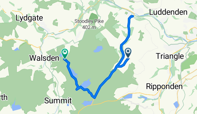
Part one of the Grand Old Duke takes you out of the shop and to the main road. Ride down Cragg Road to the Longest Gradient sign, then turn and retrace your route back up nearly to the top. Turn right and follow the map to where the path ends, and then push across the short piece of open moorland to the Gadding's Dam. Here's where you can do your swim...or ride on by!
- -:--
- Duration
- 21 km
- Distance
- 312 m
- Ascent
- 251 m
- Descent
- ---
- Avg. speed
- ---
- Max. altitude
Route quality
Waytypes & surfaces along the route
Waytypes
Busy road
14 km
(66 %)
Track
5 km
(24 %)
Surfaces
Paved
14.8 km
(70 %)
Unpaved
5 km
(24 %)
Asphalt
13.7 km
(65 %)
Gravel
5 km
(24 %)
Continue with Bikemap
Use, edit, or download this cycling route
You would like to ride Grand Old Duke Part 1 or customize it for your own trip? Here is what you can do with this Bikemap route:
Free features
- Save this route as favorite or in collections
- Copy & plan your own version of this route
- Sync your route with Garmin or Wahoo
Premium features
Free trial for 3 days, or one-time payment. More about Bikemap Premium.
- Navigate this route on iOS & Android
- Export a GPX / KML file of this route
- Create your custom printout (try it for free)
- Download this route for offline navigation
Discover more Premium features.
Get Bikemap PremiumFrom our community
Other popular routes starting in Luddenden Foot
 Way of the Rings Days 3-4 Ilkley to Matlock
- Distance
- 120 km
- Ascent
- 2,285 m
- Descent
- 2,395 m
- Location
- Luddenden Foot, England, United Kingdom
 New Way of the Rings Day Sowerby Bridge to Penistone Ilkley to Matlock
- Distance
- 49.1 km
- Ascent
- 1,145 m
- Descent
- 1,132 m
- Location
- Luddenden Foot, England, United Kingdom
 CMBM 2011
- Distance
- 42.6 km
- Ascent
- 750 m
- Descent
- 737 m
- Location
- Luddenden Foot, England, United Kingdom
 Grassington Run.
- Distance
- 137.4 km
- Ascent
- 1,476 m
- Descent
- 1,466 m
- Location
- Luddenden Foot, England, United Kingdom
 Goal 1
- Distance
- 24.6 km
- Ascent
- 491 m
- Descent
- 491 m
- Location
- Luddenden Foot, England, United Kingdom
 Training Route 2
- Distance
- 15 km
- Ascent
- 423 m
- Descent
- 227 m
- Location
- Luddenden Foot, England, United Kingdom
 cragg Road climb
- Distance
- 16.1 km
- Ascent
- 345 m
- Descent
- 362 m
- Location
- Luddenden Foot, England, United Kingdom
 Clitheroe - Settle - Skipton
- Distance
- 143.6 km
- Ascent
- 1,286 m
- Descent
- 1,284 m
- Location
- Luddenden Foot, England, United Kingdom
Open it in the app