TEKER Családi Nap
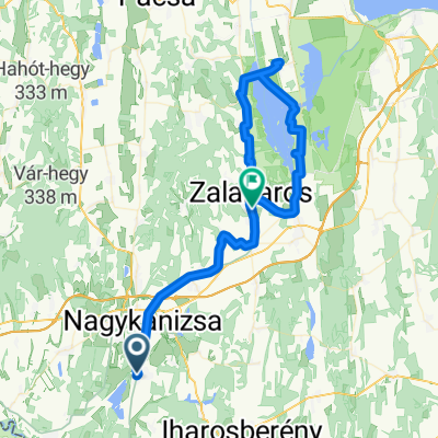
A cycling route starting in Nagykanizsa, Zala County, Hungary.
Overview
About this route
Start: 13:30 at Yanko's Bike Shop (11 Zrínyi Miklós Street)
Parade on the main road, then near the Motocross track we take the old Route 7. After Kendlimajor, we turn left and descend the Csapi hill.
Refreshment point at the Galamboki fish ponds.
Galambok, connecting road towards Zalakomár, then we return to Zalakaros on the new bike path.
At Galambok we return home on the old Route 7!
Event supporters: Yanko's Bike Shop - Placc Café - Fittlesz Training Center - Ágy City - Bikeline Ltd.
- -:--
- Duration
- 43 km
- Distance
- 260 m
- Ascent
- 260 m
- Descent
- ---
- Avg. speed
- ---
- Max. altitude
Route quality
Waytypes & surfaces along the route
Waytypes
Cycleway
6.9 km
(16 %)
Road
6.5 km
(15 %)
Surfaces
Paved
35.7 km
(83 %)
Unpaved
1.3 km
(3 %)
Asphalt
35.7 km
(83 %)
Ground
1.3 km
(3 %)
Undefined
6 km
(14 %)
Route highlights
Points of interest along the route
Point of interest after 15.2 km
Frissítőpont! Habzsi-dőzsi!
Continue with Bikemap
Use, edit, or download this cycling route
You would like to ride TEKER Családi Nap or customize it for your own trip? Here is what you can do with this Bikemap route:
Free features
- Save this route as favorite or in collections
- Copy & plan your own version of this route
- Sync your route with Garmin or Wahoo
Premium features
Free trial for 3 days, or one-time payment. More about Bikemap Premium.
- Navigate this route on iOS & Android
- Export a GPX / KML file of this route
- Create your custom printout (try it for free)
- Download this route for offline navigation
Discover more Premium features.
Get Bikemap PremiumFrom our community
Other popular routes starting in Nagykanizsa
- MURA_Kanizsa_50
- Distance
- 49.6 km
- Ascent
- 178 m
- Descent
- 178 m
- Location
- Nagykanizsa, Zala County, Hungary
- Murafölde kör 2
- Distance
- 222 km
- Ascent
- 3,042 m
- Descent
- 3,043 m
- Location
- Nagykanizsa, Zala County, Hungary
- Vörös-hegyi kör
- Distance
- 33.1 km
- Ascent
- 197 m
- Descent
- 203 m
- Location
- Nagykanizsa, Zala County, Hungary
- Murafölde kör 1
- Distance
- 220.7 km
- Ascent
- 1,244 m
- Descent
- 1,244 m
- Location
- Nagykanizsa, Zala County, Hungary
- Börzönce1
- Distance
- 65.4 km
- Ascent
- 327 m
- Descent
- 327 m
- Location
- Nagykanizsa, Zala County, Hungary
- Murafölde kör 3
- Distance
- 219.8 km
- Ascent
- 2,889 m
- Descent
- 2,891 m
- Location
- Nagykanizsa, Zala County, Hungary
- Obornak Várdomb kör
- Distance
- 14.7 km
- Ascent
- 343 m
- Descent
- 349 m
- Location
- Nagykanizsa, Zala County, Hungary
- Látóhegy - Gáspár-hegy - Nagyrécse - Bacónaki-hegy - Cserfő
- Distance
- 33.4 km
- Ascent
- 391 m
- Descent
- 390 m
- Location
- Nagykanizsa, Zala County, Hungary
Open it in the app