

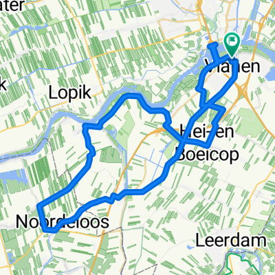
Tull - Utrecht kort
A cycling route starting in Vianen, Utrecht, The Netherlands.
Overview
About this route
Van Tull en 't Waal naar Utrecht
- -:--
- Duration
- 17.7 km
- Distance
- 9 m
- Ascent
- 0 m
- Descent
- ---
- Avg. speed
- ---
- Max. altitude

Route quality
Waytypes & surfaces along the route
Waytypes
Quiet road
10.3 km
(58 %)
Cycleway
4.1 km
(23 %)
Surfaces
Paved
12.6 km
(71 %)
Unpaved
0.4 km
(2 %)
Asphalt
12.4 km
(70 %)
Loose gravel
0.4 km
(2 %)
Route highlights
Points of interest along the route
Point of interest after 11 km
Hier wacht ik op jullie
Point of interest after 11.9 km
Let op, hier moet je van het fietspad af. Links aanhouden.
Continue with Bikemap
Use, edit, or download this cycling route
You would like to ride Tull - Utrecht kort or customize it for your own trip? Here is what you can do with this Bikemap route:
Free features
- Save this route as favorite or in collections
- Copy & plan your own version of this route
- Sync your route with Garmin or Wahoo
Premium features
Free trial for 3 days, or one-time payment. More about Bikemap Premium.
- Navigate this route on iOS & Android
- Export a GPX / KML file of this route
- Create your custom printout (try it for free)
- Download this route for offline navigation
Discover more Premium features.
Get Bikemap PremiumFrom our community
Other popular routes starting in Vianen
 ronde 1 Tour de Faas
- Distance
- 48.6 km
- Ascent
- 36 m
- Descent
- 24 m
- Location
- Vianen, Utrecht, The Netherlands
 ronde 2 Tour de Faas
- Distance
- 47.5 km
- Ascent
- 47 m
- Descent
- 50 m
- Location
- Vianen, Utrecht, The Netherlands
 Lexmond - groen hart
- Distance
- 133.1 km
- Ascent
- 35 m
- Descent
- 38 m
- Location
- Vianen, Utrecht, The Netherlands
 Langs de Lek 115k
- Distance
- 115.2 km
- Ascent
- 37 m
- Descent
- 40 m
- Location
- Vianen, Utrecht, The Netherlands
 Vianen- de Linge tour
- Distance
- 78.6 km
- Ascent
- 5 m
- Descent
- 6 m
- Location
- Vianen, Utrecht, The Netherlands
 Rondje vanaf Tull en het Waal
- Distance
- 77.8 km
- Ascent
- 11 m
- Descent
- 11 m
- Location
- Vianen, Utrecht, The Netherlands
 Rolski Plan B - 2
- Distance
- 57.1 km
- Ascent
- 20 m
- Descent
- 15 m
- Location
- Vianen, Utrecht, The Netherlands
 Vianen- Rhenen -Elst - Leesum Odijk- N gein 95 km
- Distance
- 94.5 km
- Ascent
- 82 m
- Descent
- 81 m
- Location
- Vianen, Utrecht, The Netherlands
Open it in the app