

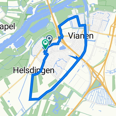
Rondje vanaf Tull en het Waal
A cycling route starting in Vianen, Utrecht, The Netherlands.
Overview
About this route
- -:--
- Duration
- 77.8 km
- Distance
- 11 m
- Ascent
- 11 m
- Descent
- ---
- Avg. speed
- ---
- Max. altitude

Route quality
Waytypes & surfaces along the route
Waytypes
Quiet road
49.8 km
(64 %)
Cycleway
14 km
(18 %)
Surfaces
Paved
43.6 km
(56 %)
Unpaved
7 km
(9 %)
Asphalt
42 km
(54 %)
Ground
3.9 km
(5 %)
Route highlights
Points of interest along the route
Point of interest after 1.2 km
http://www.honswijk.com/Honswijk/Welkom.html
Point of interest after 4.5 km
Eventueel hier al de pont nemen als je dat leuk vindt
Point of interest after 10.3 km
Schootsveldpad ziet er spannend uit. Volgens FB kun je dit fietsen en meestal klopt dat. Ik heb dit stukje nog nooit gefietst.
Point of interest after 20.7 km
Koffie in t centrum van Leerdam
Point of interest after 33.1 km
Volgens FB website kun je hier fietsen. Fietspad
Continue with Bikemap
Use, edit, or download this cycling route
You would like to ride Rondje vanaf Tull en het Waal or customize it for your own trip? Here is what you can do with this Bikemap route:
Free features
- Save this route as favorite or in collections
- Copy & plan your own version of this route
- Sync your route with Garmin or Wahoo
Premium features
Free trial for 3 days, or one-time payment. More about Bikemap Premium.
- Navigate this route on iOS & Android
- Export a GPX / KML file of this route
- Create your custom printout (try it for free)
- Download this route for offline navigation
Discover more Premium features.
Get Bikemap PremiumFrom our community
Other popular routes starting in Vianen
 Vianen- Rhenen -Elst - Leesum Odijk- N gein 95 km
- Distance
- 94.5 km
- Ascent
- 82 m
- Descent
- 81 m
- Location
- Vianen, Utrecht, The Netherlands
 Tull - Utrecht kort
- Distance
- 17.7 km
- Ascent
- 9 m
- Descent
- 0 m
- Location
- Vianen, Utrecht, The Netherlands
 Vianen- de Linge tour
- Distance
- 78.7 km
- Ascent
- 4 m
- Descent
- 5 m
- Location
- Vianen, Utrecht, The Netherlands
 rondom vijfherenlanden
- Distance
- 9.9 km
- Ascent
- 3 m
- Descent
- 48 m
- Location
- Vianen, Utrecht, The Netherlands
 Vianen- de Linge tour
- Distance
- 78.6 km
- Ascent
- 5 m
- Descent
- 6 m
- Location
- Vianen, Utrecht, The Netherlands
 Rondje vanaf Tull en het Waal
- Distance
- 77.8 km
- Ascent
- 11 m
- Descent
- 11 m
- Location
- Vianen, Utrecht, The Netherlands
 Lexmond - groen hart
- Distance
- 133.1 km
- Ascent
- 35 m
- Descent
- 38 m
- Location
- Vianen, Utrecht, The Netherlands
 Rolski Plan B - 2
- Distance
- 57.1 km
- Ascent
- 20 m
- Descent
- 15 m
- Location
- Vianen, Utrecht, The Netherlands
Open it in the app