
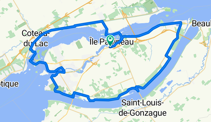
Valleyfield 2
A cycling route starting in Les Cèdres, Quebec, Canada.
Overview
About this route
- -:--
- Duration
- 66.5 km
- Distance
- 80 m
- Ascent
- 80 m
- Descent
- ---
- Avg. speed
- ---
- Max. altitude
Continue with Bikemap
Use, edit, or download this cycling route
You would like to ride Valleyfield 2 or customize it for your own trip? Here is what you can do with this Bikemap route:
Free features
- Save this route as favorite or in collections
- Copy & plan your own version of this route
- Sync your route with Garmin or Wahoo
Premium features
Free trial for 3 days, or one-time payment. More about Bikemap Premium.
- Navigate this route on iOS & Android
- Export a GPX / KML file of this route
- Create your custom printout (try it for free)
- Download this route for offline navigation
Discover more Premium features.
Get Bikemap PremiumFrom our community
Other popular routes starting in Les Cèdres
 100 km challenge for end of May
- Distance
- 67.1 km
- Ascent
- 136 m
- Descent
- 138 m
- Location
- Les Cèdres, Quebec, Canada
 trajet à pied
- Distance
- 5.9 km
- Ascent
- 29 m
- Descent
- 31 m
- Location
- Les Cèdres, Quebec, Canada
 Randonnée à Ste-Martine - Ormstown et St-Louis
- Distance
- 62.4 km
- Ascent
- 34 m
- Descent
- 35 m
- Location
- Les Cèdres, Quebec, Canada
 La Boucle des 4 Canaux de chez andre
- Distance
- 33.1 km
- Ascent
- 67 m
- Descent
- 65 m
- Location
- Les Cèdres, Quebec, Canada
 Boulevard Pie-XII 402, Salaberry-de-Valleyfield to Chemin du Fleuve 889, Les Cèdres
- Distance
- 7.7 km
- Ascent
- 4 m
- Descent
- 6 m
- Location
- Les Cèdres, Quebec, Canada
 Valleyfield 2
- Distance
- 66.5 km
- Ascent
- 80 m
- Descent
- 80 m
- Location
- Les Cèdres, Quebec, Canada
 Tour de cèdres
- Distance
- 51.6 km
- Ascent
- 59 m
- Descent
- 47 m
- Location
- Les Cèdres, Quebec, Canada
 De Rue Albert 49, Salaberry-de-Valleyfield à Rue Albert 44, Salaberry-de-Valleyfield
- Distance
- 26.3 km
- Ascent
- 29 m
- Descent
- 29 m
- Location
- Les Cèdres, Quebec, Canada
Open it in the app