

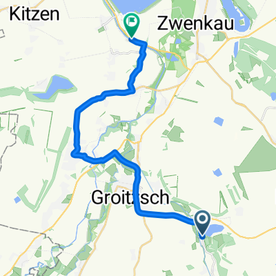
Um den Stolpener See
A cycling route starting in Groitzsch, Saxony, Germany.
Overview
About this route
Short ride in the old homeland
- -:--
- Duration
- 15.3 km
- Distance
- 50 m
- Ascent
- 54 m
- Descent
- ---
- Avg. speed
- ---
- Max. altitude

Continue with Bikemap
Use, edit, or download this cycling route
You would like to ride Um den Stolpener See or customize it for your own trip? Here is what you can do with this Bikemap route:
Free features
- Save this route as favorite or in collections
- Copy & plan your own version of this route
- Sync your route with Garmin or Wahoo
Premium features
Free trial for 3 days, or one-time payment. More about Bikemap Premium.
- Navigate this route on iOS & Android
- Export a GPX / KML file of this route
- Create your custom printout (try it for free)
- Download this route for offline navigation
Discover more Premium features.
Get Bikemap PremiumFrom our community
Other popular routes starting in Groitzsch
 Friedrich-Ebert-Straße 2, Groitzsch nach Franz-Mehring-Straße 3B, Gera
- Distance
- 53.3 km
- Ascent
- 308 m
- Descent
- 258 m
- Location
- Groitzsch, Saxony, Germany
 Groitzsch - Bad Düben
- Distance
- 70.3 km
- Ascent
- 92 m
- Descent
- 47 m
- Location
- Groitzsch, Saxony, Germany

 Markkleeberger See
- Distance
- 54.1 km
- Ascent
- 99 m
- Descent
- 102 m
- Location
- Groitzsch, Saxony, Germany
 Großstolpen-Kleindalzig
- Distance
- 16.2 km
- Ascent
- 23 m
- Descent
- 42 m
- Location
- Groitzsch, Saxony, Germany
 M+C Seenrunde
- Distance
- 71.2 km
- Ascent
- 213 m
- Descent
- 213 m
- Location
- Groitzsch, Saxony, Germany
 An den Ufern meiner Jugend.
- Distance
- 41.8 km
- Ascent
- 168 m
- Descent
- 165 m
- Location
- Groitzsch, Saxony, Germany
 An der Hohle 15, Groitzsch nach Stuttgarter Allee, Leipzig
- Distance
- 26.3 km
- Ascent
- 21 m
- Descent
- 36 m
- Location
- Groitzsch, Saxony, Germany
Open it in the app