

01_Oslo-Fredrikstad
A cycling route starting in Oslo, Oslo County, Norway.
Overview
About this route
Etappe 1 Norwegen
- -:--
- Duration
- 109.9 km
- Distance
- 439 m
- Ascent
- 545 m
- Descent
- ---
- Avg. speed
- ---
- Max. altitude

Route quality
Waytypes & surfaces along the route
Waytypes
Cycleway
42.9 km
(39 %)
Quiet road
18.7 km
(17 %)
Surfaces
Paved
79.1 km
(72 %)
Asphalt
65.9 km
(60 %)
Paved (undefined)
13.2 km
(12 %)
Undefined
30.8 km
(28 %)
Continue with Bikemap
Use, edit, or download this cycling route
You would like to ride 01_Oslo-Fredrikstad or customize it for your own trip? Here is what you can do with this Bikemap route:
Free features
- Save this route as favorite or in collections
- Copy & plan your own version of this route
- Split it into stages to create a multi-day tour
- Sync your route with Garmin or Wahoo
Premium features
Free trial for 3 days, or one-time payment. More about Bikemap Premium.
- Navigate this route on iOS & Android
- Export a GPX / KML file of this route
- Create your custom printout (try it for free)
- Download this route for offline navigation
Discover more Premium features.
Get Bikemap PremiumFrom our community
Other popular routes starting in Oslo
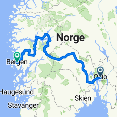 Partie 2.2 Oslo - Bergen
- Distance
- 783.8 km
- Ascent
- 17,922 m
- Descent
- 17,939 m
- Location
- Oslo, Oslo County, Norway
 Trek Bergen - Oslo : Part8 : Amot - Oslo (with a part of Silver road)
- Distance
- 87 km
- Ascent
- 445 m
- Descent
- 393 m
- Location
- Oslo, Oslo County, Norway
 Ullevål til Storo
- Distance
- 4.5 km
- Ascent
- 69 m
- Descent
- 89 m
- Location
- Oslo, Oslo County, Norway
 Maybe2022
- Distance
- 491.1 km
- Ascent
- 2,831 m
- Descent
- 2,855 m
- Location
- Oslo, Oslo County, Norway
 Sollirunden 2
- Distance
- 100.5 km
- Ascent
- 734 m
- Descent
- 734 m
- Location
- Oslo, Oslo County, Norway
 Hilse på Glomma
- Distance
- 65.6 km
- Ascent
- 320 m
- Descent
- 320 m
- Location
- Oslo, Oslo County, Norway
 OSL-HAM - Part 1 Color Line Terminal - Rykkinn
- Distance
- 17.4 km
- Ascent
- 347 m
- Descent
- 276 m
- Location
- Oslo, Oslo County, Norway
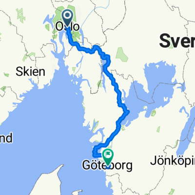 Oslo-Göteborg 1 (Unionsleden/Vänersleden))
- Distance
- 474.9 km
- Ascent
- 5,197 m
- Descent
- 5,203 m
- Location
- Oslo, Oslo County, Norway
Open it in the app