

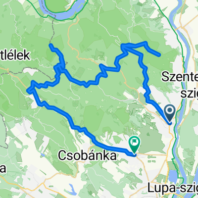
Szentendre - Csobánka - Budakalász
A cycling route starting in Szentendre, Pest County, Hungary.
Overview
About this route
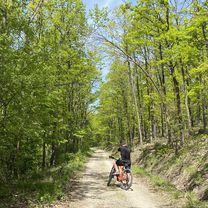
Csobánka-Budakalász közötti szakasz erdei földút, néhol homokos, saras, köves. Az a szakasz MTB-nek való túra.
- 3 h 35 min
- Duration
- 37.1 km
- Distance
- 351 m
- Ascent
- 364 m
- Descent
- 10.4 km/h
- Avg. speed
- ---
- Max. altitude

Route photos


Route quality
Waytypes & surfaces along the route
Waytypes
Quiet road
7.4 km
(20 %)
Cycleway
6.5 km
(17 %)
Surfaces
Paved
24 km
(65 %)
Unpaved
7.8 km
(21 %)
Asphalt
22.2 km
(60 %)
Ground
6.6 km
(18 %)
Route highlights
Points of interest along the route

Point of interest after 11.1 km
Csobánka
Point of interest after 16.3 km
Pihenő hely

Point of interest after 16.3 km
Pihenő
Continue with Bikemap
Use, edit, or download this cycling route
You would like to ride Szentendre - Csobánka - Budakalász or customize it for your own trip? Here is what you can do with this Bikemap route:
Free features
- Save this route as favorite or in collections
- Copy & plan your own version of this route
- Sync your route with Garmin or Wahoo
Premium features
Free trial for 3 days, or one-time payment. More about Bikemap Premium.
- Navigate this route on iOS & Android
- Export a GPX / KML file of this route
- Create your custom printout (try it for free)
- Download this route for offline navigation
Discover more Premium features.
Get Bikemap PremiumFrom our community
Other popular routes starting in Szentendre
 pap-rét melegítő
- Distance
- 18.6 km
- Ascent
- 394 m
- Descent
- 390 m
- Location
- Szentendre, Pest County, Hungary
 Szentendre - Pap-rét - Vörös-kő - Prédikálószék - Kakas-hegy - Pomáz
- Distance
- 58.2 km
- Ascent
- 1,181 m
- Descent
- 1,180 m
- Location
- Szentendre, Pest County, Hungary
 Szentendre - Csobánka - Budakalász
- Distance
- 37.1 km
- Ascent
- 351 m
- Descent
- 364 m
- Location
- Szentendre, Pest County, Hungary
 Kedvenc köröm, 123 km
- Distance
- 119.1 km
- Ascent
- 678 m
- Descent
- 678 m
- Location
- Szentendre, Pest County, Hungary
 Vörös-kő kör
- Distance
- 17.4 km
- Ascent
- 595 m
- Descent
- 595 m
- Location
- Szentendre, Pest County, Hungary
 szentendere-pilisszentlászló-visegrád-szentendre
- Distance
- 45.3 km
- Ascent
- 803 m
- Descent
- 795 m
- Location
- Szentendre, Pest County, Hungary
 szentendre-prédikálószék-pilisszentlászló-szentendre
- Distance
- 43.6 km
- Ascent
- 1,371 m
- Descent
- 1,482 m
- Location
- Szentendre, Pest County, Hungary
 Vércse próbanap
- Distance
- 81.8 km
- Ascent
- 993 m
- Descent
- 877 m
- Location
- Szentendre, Pest County, Hungary
Open it in the app