

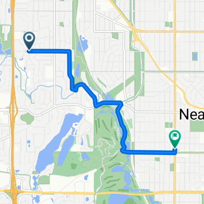
B2B00088 55411 > 55111 via downtown, Light Rail trail, and Minnehaha park
A cycling route starting in Golden Valley, Minnesota, United States.
Overview
About this route
Begin your ride by heading east on 26th Avenue North. Take 26th to North 2nd Street. Go right (south) on North 2nd. At 8th Avenue North, hop over a block to your left to North 1st Street. Take North 1st all the way to 5th Avenue South. At 5th south you will go right and jog back over to South 2nd Street. Continue on South 2nd to 11th Avenue South. At 11th, take a right, cross over Washington, go a few blocks and get on the light rail trail. This trail runs along side the train tracks and will take you all the way to Minnehaha Park.
At East 46th street, cross over Hiawatha (heading east) to Minnehaha Avenue. You will take Minnnehaha avenue into the park and all the way to the southwest corner where you will get on the bike trail that takes you to Fort Snelling. As the trail comes to Pike Island, veer right (to the west) and follow the trail / road to Snelling lake.
- -:--
- Duration
- 18.8 km
- Distance
- 39 m
- Ascent
- 95 m
- Descent
- ---
- Avg. speed
- ---
- Max. altitude

Route highlights
Points of interest along the route
Point of interest after 7.2 km
Look for the Light Rail Trail here.
Point of interest after 16.1 km
Get on the bike trail here. It will take you to Fort Snelling.
Continue with Bikemap
Use, edit, or download this cycling route
You would like to ride B2B00088 55411 > 55111 via downtown, Light Rail trail, and Minnehaha park or customize it for your own trip? Here is what you can do with this Bikemap route:
Free features
- Save this route as favorite or in collections
- Copy & plan your own version of this route
- Sync your route with Garmin or Wahoo
Premium features
Free trial for 3 days, or one-time payment. More about Bikemap Premium.
- Navigate this route on iOS & Android
- Export a GPX / KML file of this route
- Create your custom printout (try it for free)
- Download this route for offline navigation
Discover more Premium features.
Get Bikemap PremiumFrom our community
Other popular routes starting in Golden Valley
 B2B00321 55442>55411 via Culver Rd, Kyle Ave, Theo Wirth Pkwy & Plymouth Ave
- Distance
- 5 km
- Ascent
- 37 m
- Descent
- 37 m
- Location
- Golden Valley, Minnesota, United States
 6/28/19
- Distance
- 17.9 km
- Ascent
- 74 m
- Descent
- 77 m
- Location
- Golden Valley, Minnesota, United States
 Trip to Wayzata
- Distance
- 18.8 km
- Ascent
- 108 m
- Descent
- 76 m
- Location
- Golden Valley, Minnesota, United States
 44 Mile Tour D'Amico
- Distance
- 66.9 km
- Ascent
- 201 m
- Descent
- 201 m
- Location
- Golden Valley, Minnesota, United States
 Theo Wirth Area MTB Trails
- Distance
- 14.8 km
- Ascent
- 81 m
- Descent
- 93 m
- Location
- Golden Valley, Minnesota, United States
 edina route66
- Distance
- 46.2 km
- Ascent
- 116 m
- Descent
- 117 m
- Location
- Golden Valley, Minnesota, United States
 B2B00649 55411>55344 via Luce Line, Plymouth Rd, Baker Rd
- Distance
- 28.3 km
- Ascent
- 155 m
- Descent
- 160 m
- Location
- Golden Valley, Minnesota, United States
 Loop 5/20/20
- Distance
- 14.8 km
- Ascent
- 95 m
- Descent
- 93 m
- Location
- Golden Valley, Minnesota, United States
Open it in the app