

ride through Town of Windsor
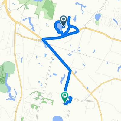
A cycling route starting in Tariffville, Connecticut, United States.
Overview
About this route
- 40 min
- Duration
- 12.6 km
- Distance
- 68 m
- Ascent
- 114 m
- Descent
- 18.8 km/h
- Avg. speed
- ---
- Max. altitude

Route photos

Route quality
Waytypes & surfaces along the route
Waytypes
Quiet road
1.6 km
(13 %)
Road
0.5 km
(4 %)
Surfaces
Paved
1.3 km
(10 %)
Asphalt
1.3 km
(10 %)
Undefined
11.3 km
(90 %)
Continue with Bikemap
Use, edit, or download this cycling route
You would like to ride ride through Town of Windsor or customize it for your own trip? Here is what you can do with this Bikemap route:
Free features
- Save this route as favorite or in collections
- Copy & plan your own version of this route
- Sync your route with Garmin or Wahoo
Premium features
Free trial for 3 days, or one-time payment. More about Bikemap Premium.
- Navigate this route on iOS & Android
- Export a GPX / KML file of this route
- Create your custom printout (try it for free)
- Download this route for offline navigation
Discover more Premium features.
Get Bikemap PremiumFrom our community
Other popular routes starting in Tariffville
 Blistering ride in East Granby
- Distance
- 41.1 km
- Ascent
- 329 m
- Descent
- 334 m
- Location
- Tariffville, Connecticut, United States
 Windsor to Filley St, Bloomfield
- Distance
- 8.5 km
- Ascent
- 30 m
- Descent
- 46 m
- Location
- Tariffville, Connecticut, United States
 10 Metacomet Dr, East Granby to 10 Metacomet Dr, East Granby
- Distance
- 48.8 km
- Ascent
- 81 m
- Descent
- 161 m
- Location
- Tariffville, Connecticut, United States
 North Congamond Lake
- Distance
- 46.4 km
- Ascent
- 217 m
- Descent
- 217 m
- Location
- Tariffville, Connecticut, United States
 36 Salmon Brook St, Granby to 107 Congamond Rd, Southwick
- Distance
- 36.7 km
- Ascent
- 437 m
- Descent
- 425 m
- Location
- Tariffville, Connecticut, United States
 36 Salmon Brook St, Granby to 140 Main St, Collinsville
- Distance
- 20.9 km
- Ascent
- 164 m
- Descent
- 126 m
- Location
- Tariffville, Connecticut, United States
 Pine tree down Wolcott Rd Simsbury
- Distance
- 1.2 km
- Ascent
- 4 m
- Descent
- 8 m
- Location
- Tariffville, Connecticut, United States
 Sporty route in East Granby
- Distance
- 22.6 km
- Ascent
- 113 m
- Descent
- 117 m
- Location
- Tariffville, Connecticut, United States
Open it in the app