

Okolo Banskej Štavnice
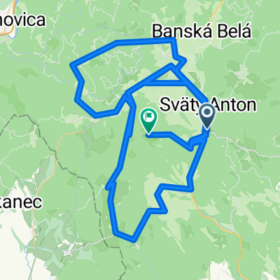
A cycling route starting in Svätý Anton, Banská Bystrica Region, Slovakia.
Overview
About this route
Banský Studenec-Antol-Ilija-Počúvadlo-Horná Roveň-Červená Studňa-Banská Štiavnica-Banský Studenec
- -:--
- Duration
- 38.4 km
- Distance
- 719 m
- Ascent
- 693 m
- Descent
- ---
- Avg. speed
- ---
- Max. altitude
Route quality
Waytypes & surfaces along the route
Waytypes
Track
16.1 km
(42 %)
Road
11.9 km
(31 %)
Surfaces
Paved
10.7 km
(28 %)
Unpaved
12.7 km
(33 %)
Asphalt
10 km
(26 %)
Unpaved (undefined)
6.1 km
(16 %)
Continue with Bikemap
Use, edit, or download this cycling route
You would like to ride Okolo Banskej Štavnice or customize it for your own trip? Here is what you can do with this Bikemap route:
Free features
- Save this route as favorite or in collections
- Copy & plan your own version of this route
- Sync your route with Garmin or Wahoo
Premium features
Free trial for 3 days, or one-time payment. More about Bikemap Premium.
- Navigate this route on iOS & Android
- Export a GPX / KML file of this route
- Create your custom printout (try it for free)
- Download this route for offline navigation
Discover more Premium features.
Get Bikemap PremiumFrom our community
Other popular routes starting in Svätý Anton
 Szczawnickie 1
- Distance
- 56.9 km
- Ascent
- 933 m
- Descent
- 934 m
- Location
- Svätý Anton, Banská Bystrica Region, Slovakia
 okruh pod Sitnom
- Distance
- 29.8 km
- Ascent
- 577 m
- Descent
- 579 m
- Location
- Svätý Anton, Banská Bystrica Region, Slovakia
 Klastava_Sitno_Pocuvadlo_Klastava_2018 (38km)
- Distance
- 37.6 km
- Ascent
- 794 m
- Descent
- 795 m
- Location
- Svätý Anton, Banská Bystrica Region, Slovakia
 2562, Žibritov do Nová 207
- Distance
- 9.6 km
- Ascent
- 76 m
- Descent
- 306 m
- Location
- Svätý Anton, Banská Bystrica Region, Slovakia
 ride from Banský Studenec to Štiavnické Bane
- Distance
- 14.1 km
- Ascent
- 576 m
- Descent
- 489 m
- Location
- Svätý Anton, Banská Bystrica Region, Slovakia
 Pocuvadlo-sitno
- Distance
- 10.4 km
- Ascent
- 379 m
- Descent
- 432 m
- Location
- Svätý Anton, Banská Bystrica Region, Slovakia
 okolo sitna
- Distance
- 38.4 km
- Ascent
- 847 m
- Descent
- 842 m
- Location
- Svätý Anton, Banská Bystrica Region, Slovakia
 Sitno extrem cesta
- Distance
- 147.2 km
- Ascent
- 2,606 m
- Descent
- 2,011 m
- Location
- Svätý Anton, Banská Bystrica Region, Slovakia
Open it in the app