

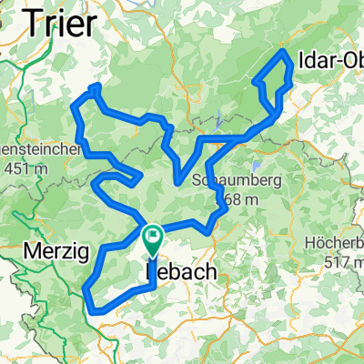
20160612_121224.gpx
A cycling route starting in Schmelz, Saarland, Germany.
Overview
About this route
TEASI track
- -:--
- Duration
- 55.2 km
- Distance
- 698 m
- Ascent
- 719 m
- Descent
- ---
- Avg. speed
- ---
- Max. altitude
Route quality
Waytypes & surfaces along the route
Waytypes
Track
28 km
(51 %)
Quiet road
12.4 km
(22 %)
Surfaces
Paved
28 km
(51 %)
Unpaved
21.3 km
(39 %)
Asphalt
21.7 km
(39 %)
Gravel
18 km
(33 %)
Continue with Bikemap
Use, edit, or download this cycling route
You would like to ride 20160612_121224.gpx or customize it for your own trip? Here is what you can do with this Bikemap route:
Free features
- Save this route as favorite or in collections
- Copy & plan your own version of this route
- Sync your route with Garmin or Wahoo
Premium features
Free trial for 3 days, or one-time payment. More about Bikemap Premium.
- Navigate this route on iOS & Android
- Export a GPX / KML file of this route
- Create your custom printout (try it for free)
- Download this route for offline navigation
Discover more Premium features.
Get Bikemap PremiumFrom our community
Other popular routes starting in Schmelz
 "Auf den Schaumberg"
- Distance
- 42.6 km
- Ascent
- 784 m
- Descent
- 780 m
- Location
- Schmelz, Saarland, Germany
 Hochwaldtrail
- Distance
- 69.7 km
- Ascent
- 767 m
- Descent
- 767 m
- Location
- Schmelz, Saarland, Germany
 Limbach zur Saarschleife
- Distance
- 65.1 km
- Ascent
- 622 m
- Descent
- 622 m
- Location
- Schmelz, Saarland, Germany
 Limbach zu Burg Dagstuhl
- Distance
- 21.2 km
- Ascent
- 266 m
- Descent
- 266 m
- Location
- Schmelz, Saarland, Germany
 2019 Möven geführt 31km
- Distance
- 31.3 km
- Ascent
- 418 m
- Descent
- 418 m
- Location
- Schmelz, Saarland, Germany
 Rund um Schmelz/ Hüttersdorf
- Distance
- 17.6 km
- Ascent
- 188 m
- Descent
- 190 m
- Location
- Schmelz, Saarland, Germany
 Mövenmarathon 2008 - Marathon des RV Möve Schmelz e.V. - 202 km Strecke
- Distance
- 198.6 km
- Ascent
- 2,021 m
- Descent
- 1,834 m
- Location
- Schmelz, Saarland, Germany
 Gipfel-Trail
- Distance
- 33.9 km
- Ascent
- 509 m
- Descent
- 509 m
- Location
- Schmelz, Saarland, Germany
Open it in the app